Saturday, April 20, 2013

Wildcats Traverse - 4-6-2013

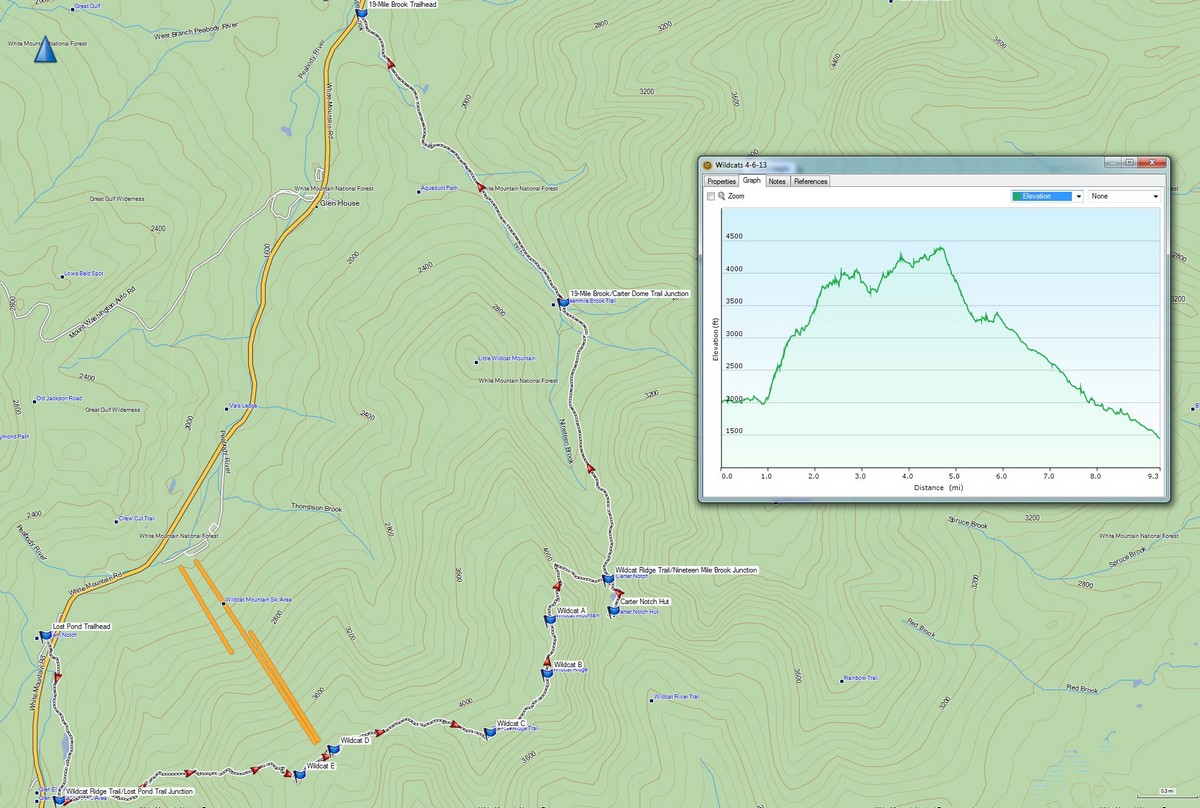
While the skies were clear, the winds were high, and so HossInNH and I abandoned plans to hike in the Northern Presidentials and instead set our sights on the Wildcats, which he still needed for his 4000-Footer list. With the trails becoming compacted with some warmer temps and then a recent stretch of cold, I convinced him to do a traverse of the whole ridge. We left a car at the 19-Mile Brook Trailhead, drove down the road to Pinkham Notch, found a parking spot (the lot was packed with skiers getting ready to head into Tuckerman's Ravine for its infamous skiing).

Crossing Route 16, we headed off on the Lost Pond Trail, which was packed rock-hard (we had to put the microspikes on immediately), but all of the rocky nature of this trail was still buried, so it was an easy warm-up.

Lost Pond

Beaver Dam on Lost Pond
After the nearly 1-mile warmup, the Wildcat Ridge Trail enters (the lower 1/10 mile of this trail is not recommended due to a tricky river crossing), and almost immediately the climbing begins. The 2-mile stretch from here to Wildcat E has 2 very steep sections, with several tricky ledges (a few have steps mounted to the rock slabs). There are some tremendous views to be had from these ledges however, and with clouds quickly lifting off of the presidential peaks, we got to enjoy these views. Only very briefly though, as the temperature was oddly chilly (even sheltered in the trees it felt colder than any other winter hike this year, though it wasn't terribly cold according to the thermometer) and the wind was quite stiff and biting. This stretch of trail, as opposed to my trip through here in January 2012 (where the trail was unbroken powder and very hard work to ascend), was frozen with a crusty surface. Crampons were the order of the day here, though I used Hillsound Trail Crampon Pros (which are an in-between of light traction and full-on crampons) and they were mostly perfect for me. The trail was still steep, but didn't seem quite so bad this time. All of the ledges were fairly simple to climb, including a chimney-like section near the bottom of the trail that last year we had to bushwhack around.

Somewhat obscured view South down Route 16


Boott Spur (R) and the Gulf of Slides

South down Route 16 towards the Pemi

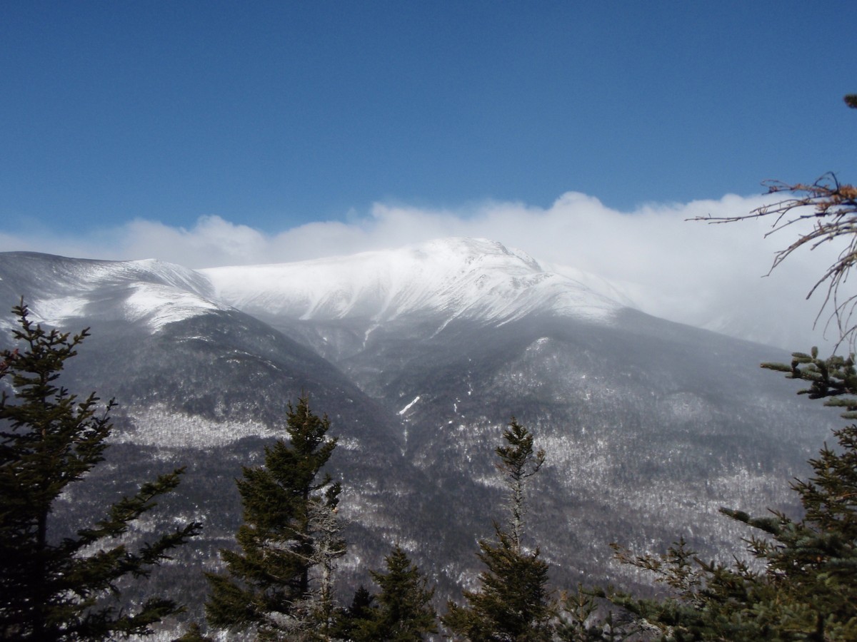
Mount Washington's head in the clouds, with Tuckerman and Huntington Ravines
It was slow, but we made our way without incident to Wildcat E, which used to be on the 4000-footer list until being replaced with Wildcat D, a couple tenths of a mile away on the ridge. Passing through the shallow col between these 2 peaks, we naturally had to stop to take pictures of the skiers getting off the Wildcat chairlifts.

Wildcat Ski Area's upper chairlift

Wildcat chair lift, with Mount Washington in the background
Once on the ridge, we switched over to snowshoes to keep from post-holing (not only is it uncomfortable, but it can cause a hazard for hikers coming after you if those post-holes freeze into an icy hole). Once completing the short climb from the ski lift to Wildcat D, we stepped out onto the observation platform (most of the steps to it were still buried!), and enjoyed the terrific nearly-360-degree views.

East towards Maine

The Northern Presidentials from Wildcat D

HossInNH recording the awesome view of Mount Washington from Wildcat D

Mount Washington, Tuckerman Ravine (L) and Huntington Ravine (R)
The only significant col on the ridge is between Wildcat D and C, and it was a pretty easy snowshoe. On the climb to C, which is somewhat like a stair-step (short, steep sections with flat stretches between), there were some nice partial views of the Wild River Valley as well as the other major peaks in the area. The wind was mostly blocked here, so we could enjoy these views a little more than earlier in the day.

More Wildcat peaks ahead

The Baldfaces from near Wildcat C

Doubleheads with Kearsarge North behind

Sable (L) and Chandler (R) from near Wildcat C
Once we reached the treed-in summit of Wildcat A (which is a few yards to the East of the trail proper and in the woods), we dropped down to the viewpoint (marked) nearby to see the stunning views of Carter Notch, and the Carter Notch Hut roughly 1100 feet directly below us.

The Baldfaces in the distance peeking out from behind Carter Dome (L)

Carter Dome from Wildcat A overlook

Carter Notch Hut 1100 feet below

Closer view of Carter Notch Hut 1100 feet below

Wild River Wilderness (South Baldface on far left)

The old slide on the side of Carter Dome that formed the ramparts the hut was built near
From here, the broken trail ended (we only saw a few other hikers to this point, all were doing an out-and-back from Lost Pond Trail...) and we had to break trail down the steep 3/4-mile to the trail junction near the hut. Partway down we met a pair hiking up (in crampons, so the trail they broke out was rather narrow but still they helped some!). There is an old slide shortly before the bottom that the trail traverses. In certain conditions this crossing can be dangerous as the slide leads off a drop and a slide means you will go a ways, but the snow was grippy enough that we had no trouble crossing it. From there, we headed to then hut for a break, before heading out to the waiting car. The exit hike on 19-Mile Brook Trail was uneventful as usual, and before long we were back at Pinkham Notch and parting ways.

And with that, HossInNH was down to a mere 4 peaks left on his New Hampshire 4000-Footer list! Congrats! This hike also brought me almost to 1/2-way on my planned 2013 circuit of the New Hampshire list too. It might be April, but this was one of the more wintry hikes of the year thus far for me!

Crossing one of the Carter Notch lakes near the hut
Summary:
Trails: Lost Pond Trail, Wildcat Ridge Trail, 19-Mile Brook Trail
Peaks: (Wildcat E (4046'), Wildcat D (4062', NH4K), Wildcat C (4298'), Wildcat B (4320'), Wildcat A (4422', NH4K)
Mileage: 9.7 miles
Elevation Gain: 3550ft
Book Time: 6hr 40min (actual 8hr 15min)


Tuesday, April 2, 2013

Cannon - Still no Views... - March 24, 2013

Yes, I have yet to get a view from the summit of Cannon Mountain that wasn't the inside of a cloud. And this hike was no different. But this was easily my most enjoyable hike of Cannon of the 3 I've done now. HossInNH had a need for revenge on Cannon after getting turned back about 1/4 mile from the summit a few weeks before, and I was game for it. Even better, he agreed to take Hi-Cannon Trail up, the last main trail to the summit of Cannon that I had not hiked yet. Bonus!

Leaving Lafayette Place with the weather forecast calling for skies clearing later in the day, but a solid cloud deck at roughly 3000 feet, we weren't expecting much for views. But we were hoping for at least a partially-broken trail, but with no recent intel since a foot or more of snow fell less than a week prior, we had the plan B of turning around if it was too jmch for 2 and driving up the road to the Kinsman Ridge Trail and bagging the summit that way.

Snowshoes went on at the trailhead sign at the parking lot just before the footbridge over a stream, and stayed on until our return to the cars. The first couple of tenths of a mile on Lonesome Lake Trail were easy and we saw several people heading to and from Lonesome Lake Hut. Reaching the junction with the Hi-Cannon Trail, we saw a snow-filled snowshoe trench with some bare boot prints through it. The depth was only 4-6" and so the going wasn't bad, and we began the ascent.

The first part of this trail is straight-forward and climbs steadily but not steeply. But soon it steepened as expected, and we passed the barebooters we'd been following the tracks of. Not a snowshoe to be seen among the three of them, boy they had to be tired from postholing 8" with each step... Here we took the lead and steadily made our way up the steepening grade, passing some small lookouts to Franconia Notch below, and one of Lonesome Lake as well where we could see people walking across the ice-covered lake.

I-93 through Franconia Notch

Lafayette Place below - we started there
Then we hit the infamous ladder mentioned in the guidebook. Only we didn't see the ladder at first (though we suspected, rightly so, that it was in the snow beneath us). Kicking steps up the steep slope, we struck ladder rungs, so we cleared those off and used them to climb on. This was simple enough, but then the step off the ladder onto a snowy chute with a definite no-slide zone was a little tricky, but with care and the help of a couple well-placed trees, we managed safely.

There is a ladder underneath all of this
From there, the trail was steep, but not horribly so, and we made steady, though slow, progress upward through deepening snow. We figure there was about a foot of unbroken snow in the upper 1/3 of this trail. The bigger annoyance was due to how deep the snow was here, now the tree canopy that is normally over your head in summer was chest-height and we were getting a lot of snow dumped down our backs. Switching to shells (and HossInNH had a hood on his shell so he got to go first now :) ) we finished off the final push to the junction with the Kinsman Ridge Trail 1/2 mile from the summit. From here it was an easy, moderate final couple hundred foot ascent to the rime-caked observation tower. Climbing to the top, we felt the heavy winds for the first time on the day. They weren't bad, but we didn't hang out long, just enough to get a couple pictures, then we returned to the Hi-Cannon junction for some snacks and a break.

Rime-caked tower on the observation platform

Cable supports caked in rime too

He looks frosty too!

A fellow hiker admires the "awesome" view of a cloud's insides
Having decided earlier that we would not attempt to descend the tricky sections of Hi-Cannon Trail, we followed the broken-out Kinsman Ridge Trail down to the col between Cannon Mountain and the NorthEast Cannonball (the col is named Coppermine Col). This section is an extremely steep section as I remembered, and we did an extensive amount of descent on our behinds, enjoying some terrific butt-sledding down to the col. Here we were presented with a nice view below the clouds to the West into Vermont.

To the West from Coppermine Col

NorthEast CannonBall from Coppermine Col - on the New England 100 Highest
From the col, we took the Lonesome Lake Trail down to Lonesome Lake, enjoying a little more butt-sledding in a few steeper sections, but otherwise enjoying easy snowshoeing conditions to the lake. From there we opted to take the Around-Lonesome-Lake Trail (which we had to break out, but it is flat and only 3/10 of a mile long, so it wasn't a big deal) to Lonesome Lake Hut. A short stay at the hut, and then we followed the established path across the center of the lake, before following the remainder of the Lonesome Lake Trail back to the cars.

Cannon Mountain and the Northeast Cannonball (L) from Around-Lonesome-Lake Trail

Solid cloud deck just above 4000 feet covering Franconia Ridge

Cannon from the center of Lonesome lake

Franconia Ridge from Lonesome Lake

The Kinsmans from Lonesome Lake
A fun snowshoe, some proper trail-breaking, two more trails red-lined for me, a successful summit of New Hampshire 4000-Footer #40 for HossInNH (congrats!), and we were still done early due to the short distance involved. Can't beat it!

Summary:
Peaks: Cannon Mountain (4100', NH4K)
Trails: Lonesome Lake Trail, Hi-Cannon Trail, Kinsman Ridge Trail, Around-Lonesome-Lake Trail, walk across the center of Lonesome Lake
Mileage: 6.4 miles
Elevation Gain: 2400'
Book Time: 4hr 25min (actual 5hr 20min)


Sunday, March 31, 2013

Mount Hale via the FireWarden's Trail - March 23, 2013

It had been 2 weeks since finishing my New Hampshire Winter 4000-Footer list, and calendar winter was over. But winter hadn't gotten the memo. On the first day of spring, the White Mountains received around a foot (or more!) of new snow, depending on location. And I wasn't quite ready to let winter go either. With the more snow on the ground than there really had been all winter (and it's been a very snowy winter, especially since the beginning of February!), it was a great time for another snowshoe, this time without any real care towards list or the like. With high winds in the forecast (80-100 predicted for the higher summits) and the day predicted to be mostly cloudy, something nice and protected in the trees was in order.

I had no real hike calling to me on this day, but decided I would head to Crawford Notch and hike Field, Willey, and Tom. But as I was driving South through Twin Mountain, I passed Zealand Road where a couple of hikers were about to set off. A light bulb went off somewhere reminding me that I had wanted to hike Hale via the long-abandoned FireWarden's Trail in winter, and what better day to do it than a windy, cloudy day that promised no views?

So I turned around, drove the couple miles to Little River Road, and parked in the turn-around at the end of that road, getting the second-to-last spot. In a few minutes, I set off ahead of a couple of people getting skis on their feet, but a few minutes behind another, larger group of skiers. The FireWarden's Trail is a very popular trail with backcountry skiers, as it passes through a large expanse of open birch glades, so I was not surprised to see a bunch of skiers would be around on this day.

Leaving the parking lot, I crossed the snowmobile bridge (having to climb over the gate is a rough start to the day mind you...) and immediately took a left onto the winter herd path to the North Twin trailhead. This herd path follows what looks to be an old railroad grade most of the way and pops out right at the bridge over Little River at the trailhead. From there I took the North Twin Trail, until the trail makes its first crossing of Little River. Here I took the herd path bypass, which was the only way that had seen traffic. Soon I crossed the tributary brook on a weakening snow bridge (this bridge is propbably gone by the time of this writing, or will soon be if not) and in short order I was at the turn off for the abandoned Fire Warden's Trail. Here I passed the large group of skiers and headed up the trail.

Along the old rail grades to the North Twin trailhead

Little River from the bridge at the North Twin trailhead

Large ice bulges along the North Twin Trail

Lower crossing of Little River - took the bypass instead

To this point I had been enjoying a great snowshoe on a trail well-packed by the backcountry skies, but now I had only a single set of ski tracks ahead of me, possibly from the day before. But the FireWarden's Trail corridor was obvious, even without the tracks heading ahead of me, and I enjoyed a terrific snowshoe ascent along the gentle grades of this route all the way to near the ridge, where the skier had headed downhill once the glades ended. From here I was breaking out the trail, but it wasn't hard, and aside from a drifted section near the viewpoint on the ridge, the corridor was still easy to follow.

A sole set of ski tracks heading up the abandoned Fire Warden's Trail

The skier headed down through the birch glades here

A seat-like tree high on the Fire Warden's Trail

The summit of Hale is nothing to get excited about. It once held a fire tower (serviced via the route I had just ascended, which was a tractor grade hence the easy ascent), but the tower was removed over 40 years ago, and the trees, once small and allowing what was apparently a terrific summit vista, have grown up and all the summit has to offer is a large clearing with a giant pile of rocks serving as a summit carin. Here the wind was blowing stiffly through the trees, but the solid cloud deck had a few tiny holes in it where I could see blue skies briefly. After waving at a shy gray jay (first one I've ever seen that showed no interest in scavenging food off me!) I ducked back onto the trail and headed down a little out of the wind for snacks (my fingers were also not thrilled with the cold, nor was my camera which started to rebel, hence not a ton of pictures...

Hale's summit carin

A peek through the clouds towards the Presidentials from the abandoned Fire Warden's Trail

The trip back down was more wonderful snowshoeing, with lots of evidence of where the skiers had come up to near the ridge then headed back down through the glades (versus the trail). I saw even more of them coming up as I descended, and in fact I only saw 2 other people that WEREN'T on skies (both were on snowshoes) and one of them had a snowboard on-board for descent. It was a quicker hike, but a very enjoyable one. The birch glades of Hale are wonderful in winter even if you aren't a skier, but boy did those skiers seem to be having a blast heading down through the powder!

Summary:
Peaks: Hale (4054', NH4K)
Trails: Herd Path, North Twin Trail, abandoned Fire Warden's Trail
Mileage: 9 miles
Elevation Gain: 2550'
Book Time: 5hr 45min