That peak is Mount Nancy. Nancy is situated just South of Crawford Notch, a couple miles from route 302. The normal approach to this summit uses the first 4.3 miles of the Nancy Pond Trail, and upon reaching the outlet of Norcross Pond, a herd path diverges steeply to the summit.
This trail has a lot for everyone. A short, fairly easy trek gets you to the base of Nancy Cascades, a beautiful waterfall alongside the trail.
There is a nice pool at the bottom of the falls that would make a wonderful swimming hole. I reached this part of the trail in short order, as it is 2.4 miles and about 1450 feet of climbing, mostly along old road grades. A half-mile before the falls the trail becomes rougher and there are several heavily-eroded sections from the 2011 Hurricane Irene that roared through the North East.
At this point the trail begins to climb hard to the top of the cascades, utilizing numerous switchbacks to accomplish this. You know it is steep if the trail in the White Mountain uses switchbacks!
After this climbing, the grades moderate nicely up to the first of 2 picturesque ponds, Nancy Pond. Here the trail runs mostly level over many bog bridges along the shore of first this pond, and then Norcross Pond.
 |
| Nancy Pond |
 |
| Norcross Pond |
 |
| Mount Anderson |
At this point I had seen all of one person today, an older gentleman shortly before the base of the falls who looked to be only heading that far. I didn't really expect to see anyone above the falls, or at least not beyond the ponds. Nancy is not officially trailed, and this is a bit of a tucked-away spot. There had been 2 cars in the lot when I left though, so there was at least one more person ahead of me most likely (unless it was a car spot for someone) Nevertheless, as I neared the Norcross Pond outlet, I heard voices. There was a hiking duo resting at the outlet enjoying the view over the Pemi Wilderness towards the Bonds, where I had just been a week before!
 |
| View to the Bonds from the Norcross Pond outlet |
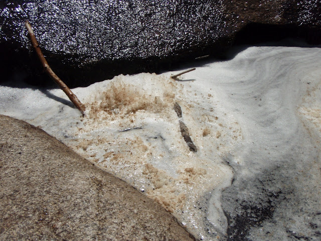
As I mentioned, Norcross Pond has some beavers hanging around. While I never saw a beaver, I did see a lodge near the edge of the pond (not far from the trail in fact) and they had a nice dam built along the outlet of the pond, raising the water level easily a solid foot.
 |
| Busy beavers |
 |
| Foamy goodness |
The herd path splits early on, with the real path going left with a spur to a well-used campsite to the right. After initially following this false spur despite knowing it wasn't right, we were soon heading up the herd path. Early on it comes to a gravel slide, where the herd path continues alongside of, one can go up the slide or up the herd path. I intended to go up the slide and down the herd path, but the slide was such loose stuff that I opted not to (it was 1 step forward, 2 steps backward territory - that loose!). But first I ventured out onto it to get some shots of Mount Anderson sitting right there on the other side of the outlet.
 |
| Mount Anderson from the Mount Nancy slide |
The summit of Nancy has a nice ledge overlooking the bottom of Crawford Notch.
 |
| Stairs Mountain. Mount Resolution, and more from Nancy's summit |
 |
| Mount Washington in the clouds |
After a break, it was time for the steep descent down, much harder than going up. But it was quicker! Then came the hike out, with a lengthy visit at the falls on the way down.
1/2 mile below the falls there is the remnants of the old Lucy Mill right along the trail, which I somehow missed most of on the way up (there is some advantage to out-and-back hikes!) There are a few metal artifacts and a few foundation blocks, but not much else. Likely the nice old roads below this point once served this mill.
Overall, an uneventful hike out with some nice company where we discussed where each had been (much of the same places, they had just finished the NH 48 last year and are now working towards the New England Hundred Highest - or at least the NE67!). I reached my car 6.5 hours after leaving it, and there was easily 1 hour of breaks in there at Norcross Pond, the summit, and the waterfall.
It was a nice day out along a very beautiful hike. Just the waterfall at 2.4 miles one-way, or the ponds between 3.4 and 4.3 miles (one-way again) are wonderful destinations by themselves, throwing the summit in there was a cherry on top!
This was only the 4th Hundred Highest peak I have visited besides the 48 NH 4000-footers (The Bulge, The Horn, and the Cannon Ball being the others, all visited en-route to 4ks), but it was a great one. (EDIT: I actually have 5, I was reminded that Sandwich Dome, at 3980', is on this list, but not the 4K list, haha).
Summary:
Peaks: Mount Nancy 3926' (NEHH)
Mileage: ~10 miles
Elevation Gain: ~3000 feet


very enlightening. thanks for the photos. and I'll remember to pack the Deet.
ReplyDeleteWhile searching for trails to hike in New England I came across your blog and enjoyed reading this post so much! I hiked to the summit with my boyfriend back in September 2014 and we can't thank you enough for the descriptions, photos and maps, etc. We will continue to follow your blog and use it for trail selections this summer. Keep up the awesomeness! Hike on!
ReplyDelete