To cap off a busy month of July (hiking-wise) I signed up for an overnight traverse of the Kilkenny Ridge. I'd been looking at doing at least a partial traverse as an overnight, but this one is tough with only one car as the trailheads are 45 minutes apart by car! The Kilkenny Ridge is the ridge that runs from Mount Waumbek up over the Weeks Ridge, Terrace, Cabot, The Bulge, The Horn, Roger's Ledge and on North to South Pond way up in Stark, NH. Only Mounts Waumbek and Cabot on this ridge rise over 4000 feet (and both are on the New Hampshire 4000-footer list), but there are a total of 4 New England 100-Highest Peaks as well, and a couple of New Hampshire 100 Highest peaks (not a list I am pursuing in any way right now). Needless to say, there's a lot up there.
At the same time, there isn't a lot up there. Cabot and Waumbek see decent traffic, but only because they are on the 4000-footer list. The Appalachian Trail doesn't run anywhere near this ridge. Neither 4000-footer has a view from the summit (and only a few small views along the way), and these 2 are the furthest North peaks on the New Hampshire 4000-footer list. Aside from The Horn, ~1.4 miles from Cabot, there are no views from any of the summits, and as such the peaks between the 4000-footers see little traffic. This trip had the makings of not seeing anyone else on the trails for a solid day. In fact, once we left Waumbek, we saw only 5 people the rest of the weekend.
The hike was another hike run through the
Random Hikers Meetup Group, a group I've done a lot of hiking with in July (all 4 Maine hikes in fact). This time we ended up with a group of 8 on this hike. After a loud, rough sleeping night in Selbourne, NH at a campground where we were about 200 feet from railroad tracks (2 LOUD freight trains came barrelling though at ~2AM and ~3AM, pretty sure they went right through our tents...), we got up, ate, and travelled up to Berlin, NH and to the Berlin Fish Hatchery, where we would be exiting the trail the following afternoon. We left a couple of cars here, piled everyone into the other cars, and drove over to Jefferson, NH to the Mount Starr King Trailhead.
The Starr King Trail ascends to Mount Starr King, a 3900' summit on the side of Waumbek (it does not have enough prominence from Waumbek to count on the NE 100-Highest), and then to Waumbek itself 3.6 miles from the road. This is the only way to access Waumbek really, but is a fairly moderately-graded trail. We saw a lot of people on the trail between the parking lot and Starr King's summit, which has a chimney from an old cabin of some sort (fire watch perhaps?) just past the summit. There used to be a very overgrown view here, it appears that it has been opened up some, but we had very cloudy weather (theme for the weekend) and so the view wasn't much. Still better than my first visit to Waumbek, where we hiked in off-and-on light rain all day.
 |
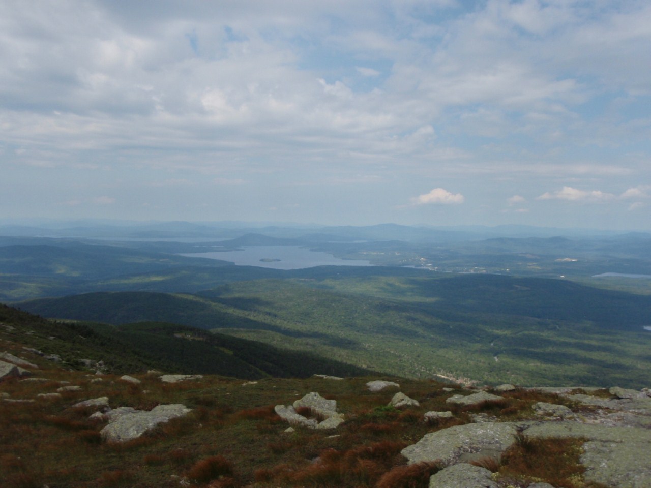
| Potential for a nice view from Mount Starr King |
We took a break here, while several more people returned from Waumbek (roughly 1 mile away). The trek from here to Waumbek is pretty flat (you only drop about 100 feet before the final 200 foot climb to Waumbek itself) and soon enough we were at the "impressive" summit of Waumbek.
 |
| End of the Starr King trail on Waumbek |
 |
| Waumbek summit carin - NH4K #39 for 2012 for me! |
Waumbek was my 39th New Hampshire 4000-footer of 2012, but more importantly, it turned out to be #47 for one member of our group! His 48th was to be on Cabot the next day. Interesting way to finish off the list, but he said he'd wanted to finish on a backpack trip, so this was a great way to do it.
Soon we were on our way again. The trail from here is far less traveled as most people just do an out-and-back of Waumbek from where we started. It meanders along the ridge, not dropping much elevation, for quite a while, through some very nice evergreen forests with lots of ferns. Shortly before the start of the descent to the col between Waumbek and South Weeks, we stopped for lunch. Resuming a while later, it was more of the same, with a gentle descent into the col in more nice woods, and then a steady, but never steep, climb to South Weeks, one of the New England 100 Highest Peaks.
There were really no views from Starr King all the way to our camp for the night, but the woods were really beautiful. Too bad the hike was spoiled by an utterly INSANE amount of blowdowns along the Weeks ridge. They ran the whole gambit, from easy step-overs and duck-unders, to tricky step-overs/crawl-unders, to navigate-arounders. None of us counted, but there were probably somewhere on the order of 3-4 dozen major blowdowns that needed removal on this route. It's remoteness and fairly light traffic undoubtably means that maintenance is sparse on this segment. The other thing we noticed was a TON of moose droppings. Apparently the moose really like this trail! We never saw any, but were on the lookout just in case. Undoubtedly our group was a little too loud for them to hang around.
Nevertheless, the hike continued, descending and climbing gently again to Middle Weeks (New Hampshire 100 Highest Peak), and again to North Weeks, the longest climb of the day after Waumbek. Somewhere along the ridge (I believe between Middle and North Weeks) we passed a pair of moose bones crossed over each other on a stump by the trail. Obviously placed here by another hiker, they were cool to look at. These are probably leg bones, and they are simply huge, it gives you an idea of how large these animals are (granted the scale does not come through in the picture too well).
 |
| Moose leg bones |
 |
| Nice, open woods along the Weeks ridge |
During the climb up North Weeks, we startled a couple of birds out of the trail. These both flew up into nearby trees and just watched us as we went by (slowly since there was a massive blowdown blocking things...). We also stopped for some pictures. These were both grouse, most likely of the infamous spruce grouse variety. There are plenty of people who have been chased back down trails by these things, with them pecking at the heads the whole way. These 2 were merely curious, and hung around for a while.
 |
| Spruce grouse, dead center in front of the tree |
 |
| Fatter spruce grouse |
 |
| He's getting ready to leave |
This was a cool encounter. As we crossed the summit of North Weeks, we heard thunder and it started to rain. HARD! It poured the whole time during our descent of North Weeks, about 1100 feet into Willard Notch, where we were to camp at an established trailside site (unofficial site though). Luckily, the rain stopped shortly after we arrived at camp, but not before we were all pretty well soaked. We set up a couple of tarps and proceeded to put tents wherever we could find room, and settled in to make dinner. It lightly rained here and there through the evening and night, though how much of that was the trees just dripping water is hard to say for sure. Dry clothes for bed felt great, as did getting out of my boots which had completely soaked through. Later reading of the data from the
Mount Washington Observatory revealed that 1.3" of rain fell that day, and I'd say a good inch or more of it fell in that one hour span!
The next day was to see us hit Cabot for Rich's 48th summit, and the weather forecast was also a bit better (no major rain called for). But first we had to climb over Terrace Mountain, on the New Hampshire 100 Highest list, and according to our trip leader, the trail was historically even rougher than the Weeks ridge (in terms of blowdowns and overgrown-ness). Apparently someone had done some work on this section, because it really wasn't bad, and there were several blowdowns recently cleared out. We made decent time up and over the 3 little summits of Terrace (only the highest has enough prominence to count for any list) and dropped to Bunnell Notch.
Here the Bunnell Notch Trail comes in from York Pond, where the cars were waiting. But we had 4 peaks to bag yet!
 |
| Arrow on sign for Cabot used to point right instead of forward it seems... |
A couple tenths on this trail, and we met the un-maintained Mount Cabot Trail (the trailhead is on private land and the landowner and the AMC have an on-going dispute over access, so the trail is not an option to ascend Cabot at this time).
 |
| Can't take this trail |
From here you climb up to Cabot Cabin, a small cabin 1/4 mile below the Mount Cabot summit that is open for anyone to stay in on a first-come-first-serve basis. It is rough, but has 4 walls and a roof and a door, so is an option for people and it does get use. We got rained on a little in the last 20-30 minutes coming up to the cabin (thankfully only a light rain, so merely a minor nuisance), and the cabin was a welcome spot to stop for lunch.
 |
| Cabot Cabin sleeps 8, 2 each per bunk (4 bunks) |
 |
| A table with padded seats for lunch! |
 |
| Only wall inside Cabot Cabin separates eating area from sleeping area |
 |
| Probably a decent view off the porch on a clear day |
 |
| Cabot Cabin |
We took a rather lengthy break here, about 1 hour, during which the rain stopped and it tried to clear up a little (not much). It would not rain for the rest of the trip! From here it is a 1/4-mile trek with only a little climbing up to the summit of Cabot, #48 for Rich, one of our group! Congrats again Rich! We had a mini-celebration if you will (a mint double-stuff Oreo for everyone!) and some pictures.
 |
| Very weathered sign near Cabot's summit |
Cabot's true summit is not actually at the sign that lists the elevation, but on a short herd path in the area to a slightly higher point. I followed a herd path to a higher spot, but never saw the small stick-sign that is supposed to mark it. I didn't look too hard though. Close enough in this case, and I was probably right next to it...
We still had a long way to go, with 3 more peaks scheduled on the day, cars to retrieve, and a long drive home. Off we went along the Kilkenny Ridge Trail, dropping steeply at first before moderating and then climbing gently to the nondescript summit of The Bulge, a New England 100 Highest Peak (3950'). Just a small carin here. From here we dropped elevation to a spur trail which leads 0.3 miles to The Horn, the best view point on the entire Kilkenny Ridge. It is steep and bouldery at the top however, but there is a bypass to the left that avoids the worst of it, which most of us utilized as the rocks were still damp from the rain.
 |
| Left path bypasses the boulders |
 |
| These were damp, the herd path bypassed them all |
At the top, we were greeted with partially clearing skies, yielding good views of the trail-less Pilot Range.
 |
| Pilot Range |
 |
| Shoulder of The Bulge towards the Pilots |
 |
| Pilot Range |
 |
| Several of these rings in the rock on the summit |
 |
| Survey marker on the summit of The Horn |
We took a nice break here before heading down. Now, the last few feet to the summit of The Horn is on a couple of massive boulders. Some of us were able to (somewhat carefully) jump up to the summit while others followed the edge of the boulder further around the left and got up much easier. On the way down, a couple of our party hopped back down the boulders, and one slipped right off the edge. Luckily, no real injury despite a pretty far fall into trees, just a few minor scrapes, but enough to get the rest of us to push through the trees around the edges of the boulder instead. If you are climbing to this summit and don't like the look of the final boulder, just keep heading straight from the herd path around a little further and an easier way up reveals itself.
 |
| One hiker working her way between the boulders, the left one is a massive slab that is the summit. No funny camera angles here! |
The Horn, incidentally, is also a New England 100 Highest Peak. I had previously climbed both The Horn and The Bulge as a part of my trip to Cabot the first time, but the revisit was great. From here it was a long, mostly gradual, descent to Unknown Pond. From here we were supposed to take a short bushwhack (fern-whack really) to the summit of Unknown Pond Peak, a New Hampshire 100 Highest Peak, but the group had been moving slowly most of the day and it was late in the afternoon. Instead we just headed down Unknown Pond Trail to the cars, arriving at the cars around 6:30!
 |
| Unknown Pond |
 |
| Heading down Unknown Pond Trail - pretty overgrown in places |
 |
| Bridge over a stream was completely broken - the stream was a mere trickle... |
It was a long weekend, and the rain/thunderstorm on Saturday was annoying, but overall it was a fun weekend. It was a great group, everyone had great spirits and really we were all smiling most of the weekend. We bagged a LOT of peaks, got to help someone finish their New Hampshire 4000-Footers, and picked up 4 other peaks towards the New England 100-Highest. Really the only downside for me was finding out that something was wrong with my new boots, as when I splashed in a small puddle coming down Unknown Pond Trail, I felt water come in the boots almost immediately. Probably explains why they soaked through so fast in the rainstorm too...Nothing is waterproof, but they shouldn't flat out leak...I exchanged them on the chance it was just a defective pair. Time will tell.
Summary:
Peaks: Starr King (3900'), Waumbek (4006', NH4K), South Weeks (3885', NEHH), Middle Weeks (3684', NHHH), North Weeks (3901', NEHH), Terrace (3655', NHHH), Cabot (4170', NH4K), The Bulge (3950', NEHH), The Horn (3905', NEHH)
Distance: 9.8 miles (Day 1), 11.6 miles (Day 2),
21.4 miles total
Elevation Gain: 3900 feet (Day 1), 3200 feet (Day 2),
7100 feet total
 |
| Elevation Profile - Camped at the first big dip (Willard Notch) at the 10mi mark |