With yet another nice day on tap, Chris, Will, and I headed about 15 minutes out from our campsite at Rangeley Lake to the Appalachian Trail crossing on Maine Highway 4. This hike was to be a relatively straight-forward, though lengthy, out-and-back on the Appalachian Trail to hit these 2 peaks. Saddleback Mountain has a large alpine area (and the AT is well above treeline for about 3 miles over these 2 peaks!), and is often compared to Franconia Ridge in New Hampshire. I'd argue it is more like the Southern Presidentials instead, as there is no sharp ridgeline, but either way it proved to be a terrific hike.
After 17-18 miles the day before (my longest hike ever in fact) I was less than thrilled about a 14.6-mile hike the next day, but also knew I'd push through it and enjoy the scenery. The trail starts off easy enough, crossing a stream early on via a metal bridge of some sort. Not far after that is a wooden staircase, in rather sad shape. The treads rocked extensively when stepped on, so this part took a little care. Hopefully it will be fixed soon, especially since this trail sees a lot of thru-hiker and backpacker traffic.
 |
| With the stringers rotted out, these steps need some care. |
About 1 mile in, the trail crosses a very solid-looking gravel logging road, this is something I will have to look into if I return for a dayhike, as it cuts off 2.25 miles of woods hiking round-trip.
 |
| Good-looking logging road - wonder if cars are allowed up here? |
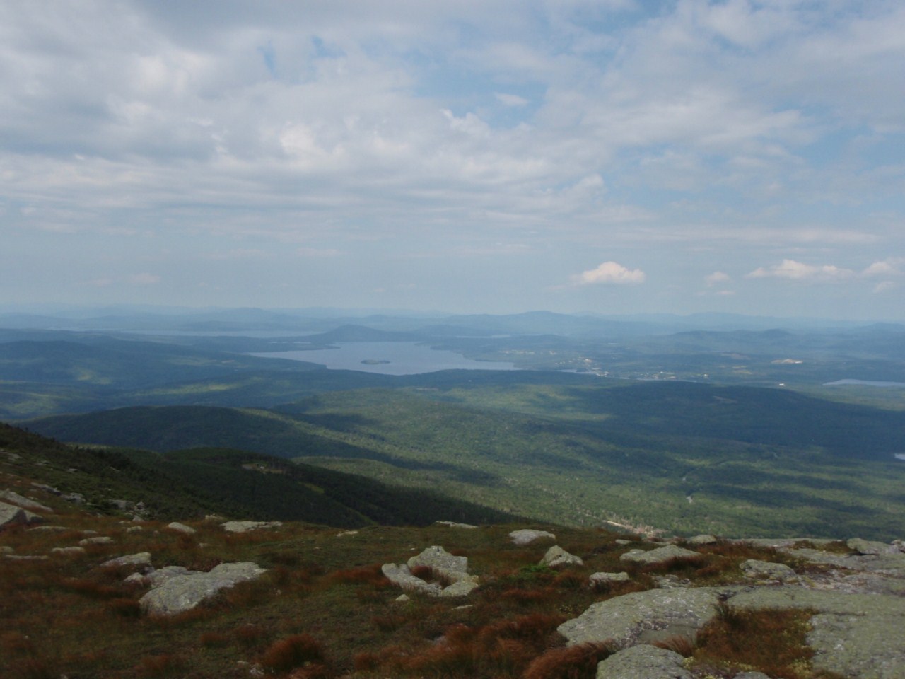
Eventually the trail passes a trailside campsite (Piazza Rock) with a side trail to Piazza Rock itself, which we did not visit on this hike. Guess I'll just have to come back someday to check it out! After a gradual up and down section, the trail climbs steeply up to the first of 2 large trailside ponds: Ethel Pond.
 |
| Ethel Pond |
Then it is a steady, though not overly steep climb up to Eddy Pond.
 |
| Helpful steel ladder rungs on this slab |
 |
| Eddy Pond North end (taken on descent) |
 |
| Eddy Pond South end (taken on descent) |
We took a break here. After a well-earned break, we continued the ascent. Just past the lake you cross an ATV trail, where the AT continues across a few yards to the left. The climb intensifies, and eventually you begin to break out of the trees with nice views Southward. This gives ample reason to stop and rest as you climb!
 |
| Eddy Pond from high up on Saddleback Mountain |
 |
| Views from the AT below Saddleback |
 |
| Views from the AT below Saddleback |
 |
| Views from AT on the climb to Saddleback |
 |
| AT marker in the trail |
Not too long after breaking treeline, the grade moderates, and turns into a nice hike along gently-sloping ledges over a number of minor summits (with no real dips so you aren't re-climbing elevation lost at least!). This really was a great section of trail, and was even better coming down with the views right in front of you.
 |
| Trail follows the carins and white blazes - look far up in the center for an arrow! |
 |
| Cresting the ridge |
 |
| Cresting the ridge again... |
 |
| There's the summit! |
 |
| View towards Spaulding/Abraham (Sugarloaf just visible on the left behind Saddleback) |
After a steady climb, I reached the top, 10-15 minutes behind my companions for this weekend (they climb way faster than I do! I actually made solid time up even!) A few more pictures, and then a break.
 |
| Caribou Valley peaks |
 |
| The Horn behind a sub-peak of Saddleback |
 |
| Views West |
 |
| Back towards where we came from - will be back in a few hours |
 |
| Hazy, but still beautiful |
 |
| Love this peak! |
 |
| To The Horn next, then back to Highway 4 |
Eventually we tore ourselves away from the summit and began the trek over to The Horn. The Maine Mountain Guide mentions that the drop from Saddleback is steep, and boy it wasn't kidding! Lots of large boulders and ledges, and a few holes to watch out for, it dropped to the col in a hurry. And it was a pretty deep col at that, at around 600 feet deep. The climb to The Horn was steady, but more gradual overall, following the high-point of the ridge for much of it.
 |
| The Horn from near Saddleback - open ridgewalk all the way |
 |
| In the col heading to The Horn |
 |
| Looking back at Saddleback Mountain from just above the col on The Horn |
 |
| Nearing the summit of The Horn |
 |
| Sugarloaf, Spaulding, and Abraham from The Horn - Saddleback Jr. in the front |
 |
| Now to head back - this was one of the few spots you could see the Saddleback ski slopes from on this hike |
 |
| The Horn on the way back to Saddleback |
After another break on The Horn, we headed back to Saddleback. The climb up was no where near as tough as anticipated, and was completed in short order. We lingered for a little longer on the summit before heading back down, but not too long as we had to drive 4.5 hours back to Boston afterwards. The descent was mostly uneventful, and we reached the cars at 3:35 after a 7:35 start, so exactly 8 hours elapsed time.
This was a hike with plenty of trail company, as there were section hikers, thru-hikers, a few day hikers, and backpackers all over this section. It seems that the 8 4000-footers South of Rt 27 (Saddleback, The Horn, Abraham, Spaulding, Sugarloaf, Redington, and the Crockers) are often done as a 3-day backpack with a car spot, since the Appalachian Trail traverses over or near all of these peaks. That's something I'd be interested in doing someday down the road for sure, but for now I can check off 10 of Maine's 14 4000-footers, putting me at 58 of the 67 New England 4000-footers completed. In a month I have a trip to Baxter State Park scheduled, which ought to take me up to 61 peaks, missing only Old Speck near the New Hampshire/Maine border and the 5 peaks in Vermont. On a side note, The Horn was my 48th 4000-footer summited this calendar year!
Thanks again to Chris from the
Random Hikers Meetup Group for organizing both of these weekends in Maine. It's too bad we never had more than 3 people for any of the hikes, but we got great weather for all of them!
 |
| The route - started on the right, The Horn on the left |
Summary:
Peaks: Saddleback (4120', NE4K), The Horn (4041', NE4K)
Distance: 14.6 miles (7.3 one-way)
Elevation Gain: ~4000 feet
Total Time: 8 hours


No comments:
Post a Comment