Sunday, February 15, 2015

Winter Wonderland on Waumbek - Jan. 25, 2015

Route: Starr King Trail
Peaks: Starr King (3900', 52WAV), Waumbek (4006', NH4K)
Mileage: 7.2 miles
Elevation Gain: 2800ft
Book Time: 5 hours (actual: 4hr 20min)

After a long day on the Bonds the day before, Theresa and I were still looking to do one more hike on Sunday. But after nearly 24 miles, it was not going to be a long or hard one. Mount Waumbek fit both of our various list goals and fit the bill on being fairly short and easy. With a sub-8 mile hike on the docket, we slept in and met at the parking lot around 8:30. We found out that the summer parking lot, while not plowed (it is not normally plowed in winter anyway), had so little snow in it that it was actually accessible, which allowed us to save a short roadwalk. Also, from trip reports from the previous couple of days, we knew that the trail was well-packed and so we left the snowshoes at the car and put on the microspikes instead. Aside from a minor bit of drifting along the ridge where there were ~3" of loose snow on top of the trench, the trail was well-packed and so leaving the snowshoes was a good call.

It was a cold morning, but there was sun in the skies, and it was looking like a fairly nice day overall. We were sore from the day before, but steadily made our way up the steady grade to Mount Starr King, passing one or two groups and being passed by many others. I had hopes of getting nice bluebird sky views from these 2 peaks for the first time ever (this was my 6th trip now), but reaching the old cabin clearing near the summit of Waumbek, we found nothing but clouds at the viewpoint. Oh well.

Sunny, though chilly, with a nice packed trail to walk on.

The packed trail continued, the clear skies did not.

The trip across the ridge, with a short drop off Starr King and then a short ascent to Waumbek, is always a very pleasant walk in the woods, and this time was no exception. It is also an easy mile to the wooded summit, and number 30 on the 4000-footer list for Theresa in winter! We walked the extra couple dozen yards to the blowdown patch just past the summit where there is a nice if restricted view, but it too was in the clouds.

The view from the blowdown path near Waumbek's summit. The skies were trying hard to clear, but couldn't manage it yet!
Waumbek Summit. The cairn is mostly buried.
Returning to Starr King, we arrived to an empty summit, aside from the 3 gray jays hanging out. One was one of the fattest gray jays I've ever seen! We played with the jays for a few minutes while eating our own snack, then headed off on the descent back to the car. After an uneventful descent, we arrived to the cars, changed into more comfortable driving footwear, and hit the road for our respective homes and work the next day. While driving South on Route 115A, I noticed that the summit ridge was now completely in the clear with blue skies all around. I've lost track of how many times I've had that happen on various hikes, but really this one was all about the hike, not the views. The woods were nice, the conversation and company was nice, and we were back home before dark!

Gray Jays!

This one was especially fat.


The skies are clearing even more during the descent as we near the cars.


Zealand and The Bonds - Jan. 24, 2015

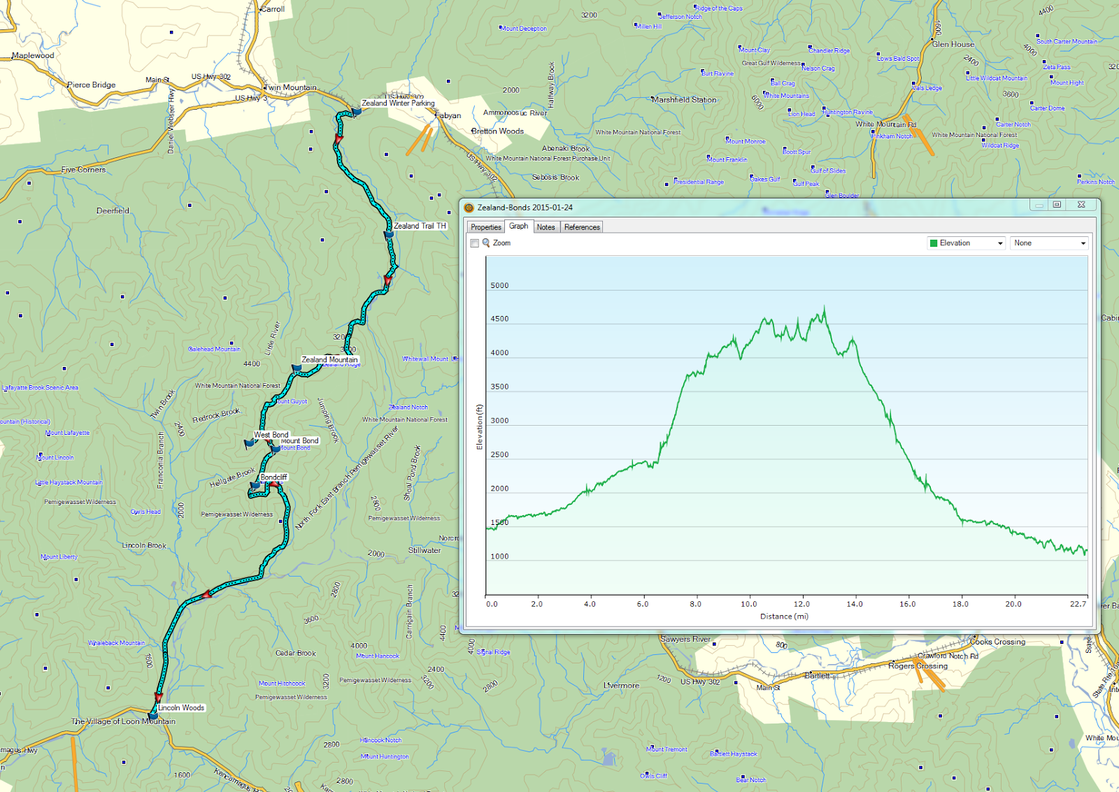
Route: Zealand Road, Zealand Trail, Twinway, Zealand Spur, Bondcliff Trail, West Bond Spur, Lincoln Woods Trail
Peaks: Zealand (4260', NH4K), Guyot (4580', TW72), West Bond (4540', NH4K), Bond (4698', NH4K), Bondcliff (4265', NH4K)
Mileage: 23.4 miles
Elevation Gain: 4600'
Book Time: 14hr (actual: 11hr 10min)

After a great trip to Maine at the beginning of the month, I took a week off from hiking and then began eying a Zealand-Bonds traverse as the weather was staying fairly stable. The first target weekend was cancelled due to weather, but as the week before this hike progressed, it was looking good for this hike. Theresa needed these peaks for her winter 4000-footer list, and both Ian and I had a hankering to get to these peaks, and so a plan was formed for the 3 of us to do the traverse. Towards the end of the week, however, I found out that Tim was heading to the same place, for his golden retriever Gryffin's 4000-footer (non-winter at the moment) finish, and had a group already lined up to head with him. So we tagged onto the group, which ended up totaling 10 human hikers and 4 canine hikers.
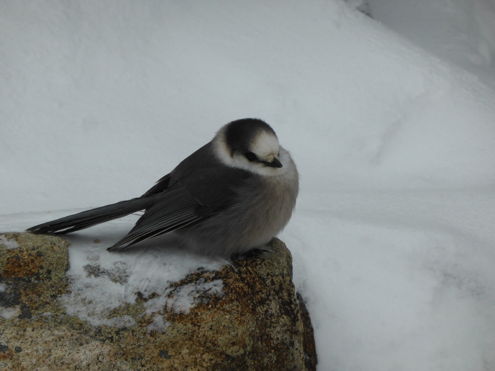
Marlie!

Gryffin, the happy golden who probably hiked/ran over 40 miles on this hike and was still bouncing around at the end.

Brent and Lucy, plus Jason. It was great to finally meet Brent and his beautiful pup after reading about their exploits.

Zealand Mountain (R) with the Zeacliff viewpoint on the left, from the Zealand beaver ponds.

Zealand Hut from the beaver ponds.

The weather forecast was a little less perfect late in the game, as it looked like the clouds were going to roll in mid-afternoon, but the temperatures and winds were to be mild, so we moved the meet time up to 5:15 at Lincoln Woods, and were on trail around 6:10 from Zealand Road. Headlamps were on for the first half hour or so of this hike, but the sky soon lightened as we motored up the road at a good pace. It is a roughly 3.75-mile road walk to the start of the Zealand Trail in winter, which we knocked off in about 1hr 15min. Fast would be the theme of this hike as it turned out. We made similarly good time up to the Zealand Hut, still bare-booting on the solid track, where we put the snowshoes on and after a snack break, we tackled the steepest, longest climb of the day up to Zeacliff. The group started to spread out a little during the climb, which turned out just as well as the dogs were all still getting used to each other. I was also having trouble getting the bindings set properly on my MSR snowshoes, which were new bindings after a trip out to Seattle for some RMA work. The views from the viewpoint were tremendous as always, despite the overcast skies. The cloud deck was way over our heads and in fact even the summit of Mount Washington was clear out of them!

The Presidential Range behind the Willey Range as seen from Zeacliff

Pano from Zeacliff

Whitewall Mountain

Mount Washington standing tall

Carrigain Notch from Zeacliff - that's Carrigain on the right


Carrigain and Vose Spur - you can just see the talus field in the col between them that offers some really cool views.


The Hancocks
After enjoying the views for a little while, we headed off up the trail towards Zealand's summit, accessed via a short spur trail after a gradual climb with a couple short steep pitches along the way. The summit had plenty of snow on it, but not as much as when I was there in March a couple years ago, where the sign was only about a foot off the snowpack. Still, this is much earlier in the season right now. Returning to the Twinway from the summit for a snack break, Alex and Chris caught up to us for the second (and not the last) time on the day. They were doing the same traverse as us, and a little ways behind them was a 9-person Meetup Group that I knew several people from (they never caught us as they climbed up the Firewarden's Trail to Hale first, for an added challenge to this lengthy hike. All in all, there were probably 30-35 people on the Bonds on this day, it was the place to be!

I love this summit sign! Probably about 3 feet of snow on the ground here.

Ian and Marlie on Guyot.
We made the short descent and then the climb up to Guyot, breaking treeline near the summit, and finding only a light breeze. I was still in my base layer at this point, and perfectly comfortable in fact! We could see our next destination, West Bond, a little ways away, along with all the usual peaks that can be seen from this area.

Bond (C) and West Bond (R) from treeline on Guyot

The Presidentials again, this time from Guyot

The Twins

Franconia Ridge

The rest of the crew heads towards West Bond, first having to climb over the Southern knob of Guyot.

Garfield (L) and South Twin (R) from Guyot

Franconia Ridge
With most of the climbing for the day out of the way, we made quick work of the descent to the spur to the Guyot Shelter (which didn't look to have seen any traffic in a while), dropped our packs at the 1/2-mile spur to West Bond, and scampered off now unencumbered, to that terrific little peak. The views are terrific from all 3 of the Bond peaks, but West Bond is a tiny summit area, fairly close to the Guyot Shelter (about 1 mile away), and is a popular spot for taking in the sunset. On this day, we had it to ourselves for a while, before we headed back to our packs, where we ran into several other hikers who had come up from Lincoln Woods.

Mount Mansfield, the high point of Vermont, was clearly visible, despite being over 70 miles away on an overcast day!

South Twin from West Bond

Bond (L) and Bondcliff (R) from West Bond

Franconia Ridge and Garfield from West Bond.

Franconia Ridge with the mass of Owl's Head in front.
We could see clouds rolling in over the Osceolas to the South, so we wasted little time in climbing up to Bond, but by the time we got there the visibility had dropped pretty abruptly and there were a few snowflakes in the air. With an exposed ridge to traverse still, we headed off pretty quickly, and made the traverse, during which time the clouds cleared up a little bit again. Most of us had our pictures taken on the infamous Bondcliff cliff, or at least close to it, as the actual rock was covered in ice and a bit treacherous. We had a short celebration on Bondcliff to congratulate Gryffin (not that he probably cares about lists!). Then it was time for the long 9-mile hike out, which starts off with a steady descent, but eventually levels off and returns to railroad grades. The first part of the descent was punctuated by some steady snow, but that lasted for only about 30 minutes. Down around the second or third crossing we took off our snowshoes and barebooted or microspiked the rest of the way out to the waiting cars.

Bondcliff from Bond - the clouds rolled in

West Bond from Bond - barely visible!

West Bond while on the way to Bondcliff - hey, things cleared up a little!

Climbing Bondcliff, with Bond looming behind.

Taking turns on Bondcliff's infamous cliff.
We had some great color in the sky for sunset on the Lincoln Woods Trail as the skies had cleared some, and we just barely needed headlamps before reaching the parking lot. We had made absolutely terrific time, just over 11 hours to traverse the over 23 miles! We'd all had a great time, it was a great hike with some great people (and dogs! I don't think I've ever hiked with 2 at once before, let alone 4!), and with a group of extremely strong hikers (including one recent grid finisher), we made quick work of this hike thanks to excellent trail conditions and weather. After ferrying everyone back North to their cars, everyone parted ways, most for home, but Theresa and I had plans to do a short hike the next morning...

Down at the old Wilderness Trail junction, now a continuation of the Bondcliff Trail. 5 miles to the cars!

Sunset lighting the sky from the Lincoln Woods Trail


Monday, February 2, 2015

Maine in Winter, Part II - Sugarloaf, Spaulding, Abraham

Date of Hike: Jan. 3, 2015
Route: Ski Trails, Sugarloaf Spur, Appalachian Trail, Spaulding Spur, Abraham Side Trail, Firewarden's Trail
Peaks: Sugarloaf (4250', NE4K), Spaulding (4010', NE4K), Abraham (4050', NE4K)
Mileage: ~15mi (trail distance is actually closer to 14.5mi, see report)
Elevation Gain: 4700ft
Time Taken: 9hr 15min

(see Chris's report, Tim's report)

With the weather for our second day in Maine expected to be good, with diminishing winds and clear summits, we were ready for another big hike. Again, since we had good snow conditions and only a couple-days-old beta, we decided that going for the other 3 peaks around the Caribou Valley Road would be a good use of time. Sugarloaf and Spaulding are fairly straight-forward to do as an out-and-back using the Sugarloaf Ski Trails (you must purchase a $10 non-lift pass, though no one ever asked to see ours). Adding Abraham turns this into a ~20-mile hike, and even more if one opts to drop down from the Abraham Side Trail/Appalachian Trail junction and bushwhack to the CVR to save the 1000-foot re-climb of Spaulding and the nearly-1000-foot reclimb of Sugarloaf. Pam and Mike, however, were looking for a shorter hike with some views.

On the drive up, Tim and I had decided to check out the access road to the Firewarden's Trail to Mount Abraham. In summer, the access starts off on a paved road, but then a couple miles in turns into an old logging road, complete with some bumps and wash boarding. Additionally, two bridges over a big stream washed out sometime around the time of Hurricane Irene (I assume it was in fact Irene that washed out the bridges), and they have not been replaced. The bridges are close together, and the first is only a few dozen yards from where one can park, and the road walk to the trailhead is only about 1/2 mile, but the crossings are significant, and a frequent source of folks needing to turn around and come back another day (or, in summer, wading very deep water). In winter, the plowed section seems to end somewhere just past the last house on the dirt portion of the road, leaving a couple-mile roadwalk to the trailhead. But Tim and I discovered an icy and bumpy, but otherwise plowed, road well past the last house (high clearance and 4WD recommended!). In fact, we got to within around 1/2-mile of the washed-out bridges before meeting a truck coming out. There were 2 guys inside that informed us that they were logging in there and that the road was plowed all the way to the bridge site and there was room to park. Additionally, they informed us that the stream looked crossable there, and that people had been hiking in there recently.

Armed with this information, our group hatched a plot over dinner after the Crockers-Redington hike. The two folks looking for a shorter hike would take the two 4WD cars in and hike Mount Abraham via the Firewarden's Trail. They would report the status of the crossings via text message/phone call to the rest of the group (since it was early in their hike, they would know soon). The rest of us, Tim Whitney, Chris, and myself, would take the 3rd car and head to Sugarloaf. We had purchased the passes the night before that allowed us to hike on the ski trails, and would hike up over Sugarloaf, Spaulding, and Abraham, descending the Fire Warden's Trail (or turning around if the streams proved to be un-crossable). If we met the others, we could all drive back together, otherwise they would leave us one of the cars with the key in an agreed-upon position and we would meet back at the cabin.

Sunrise lights the sky behind the Bigelows

The Bigelow Range


South (L) and North (R) Crocker

Redington and the Crockers from Sugarloaf (L-R), the apline ridge of Saddleback off on the left


Saddleback (LC) and Saddleback-The Horn (L) from Sugarloaf
Starting up the ski slopes shortly after sunrise, we were greeted with -3 degree air temps, but no wind. The climb up the various ski trails, chairlift lines, and access roads was steady and somewhat steep, but offered nice views across to the Bigelows. I'm pretty sure I even saw Mount Katahdin way off in the distance to the North, roughly 90 miles away! Reaching the summit, which was a tad windy, we could also see Mount Washington 70 miles away! Without hanging out too long (it was still only about 4-5 degrees), we headed off down the Sugarloaf Spur to the Appalachian Trail. The trail drops quite a ways to the col, then climbs up over a few minor bumps before finally reaching the short spur to Spaulding. There were nice views back to Sugarloaf from a viewpoint just past the summit that I somehow had missed on my summer visit a few years ago. Somewhere near the Spaulding-Sugarloaf col we received the text saying that the streams were indeed crossable and so the traverse was on!

Fairly new sign, wrong elevation...though someone did attempt to write in 4010 on the side

Saddleback and Saddleback The Horn

Mount Washington in the distance, some 70 miles away

Sugarloaf from the Spaulding viewpoint
We had some brief route-finding trouble in a few spots below the Spaulding campsite on the approach to the Abraham Side Trail, but we always found our way. White blazes and winter just don't mix! Also, there were a TON of blowdowns on the ridge, especially between Spaulding and Sugarloaf, but on this side of Spaulding too. Reaching treeline on the Abraham Side Trail, we geared up, stepped out, and found only a light breeze but overcast skies (still, the views were excellent!). We reached the summit in good time, finding the old fire tower framework had been recently knocked over somehow. Not that this open peak needed a tower to improve the views!

The final ascent to Abraham

Looking back at Spaulding and Sugarloaf - we've come a long way already!


Mount Washington looms in the distance, as seen from Abraham

Saddleback and Saddleback The Horn from Abraham

Looking across the Carrabassett Valley towards Redington and the Crockers from Abraham

The Abraham fire tower, recently knocked over (how? why? not sure)
Finding the Firewarden's Trail down proved to be a bit tricky. None of us had ever been on it, and there were no signs for it, but we found some cairns heading down the ridge a little ways. After following them for a while we determined that these were heading somewhere else (we think Middle Abraham, a de-listed New England 100-Highest Peak), and headed back towards the summit. We ran into Mike just below the summit, who let us know that Pam had to turn back at treeline due to crampon terrain. He tagged the summit real quick, then helped us down, avoiding the steep icy slopes as we too didn't have our crampons with us (a major oops on our parts! - luckily the ascent from the AT side is not steep and was not dangerously icy). This meant a bushwhack through some nasty scrub, and we went a bit too far off track, but we did get back to treeline safely. Then it was just down the steep trail to the old warden's cabin site (now a campsite with a privy), and a long flat walk out to the trailhead, during which we caught up to Pam. The crossings were indeed wide and deep, but frozen over enough for us to (carefully) cross, and we made it back to the cars before needing headlamps! Yet another terrific hike!


Our messy bushwhack around some ice fields on Abraham - you can see the actual trail corridor across the bottom of the screen.