While the skies were clear, the winds were high, and so HossInNH and I abandoned plans to hike in the Northern Presidentials and instead set our sights on the Wildcats, which he still needed for his 4000-Footer list. With the trails becoming compacted with some warmer temps and then a recent stretch of cold, I convinced him to do a traverse of the whole ridge. We left a car at the 19-Mile Brook Trailhead, drove down the road to Pinkham Notch, found a parking spot (the lot was packed with skiers getting ready to head into Tuckerman's Ravine for its infamous skiing).
Crossing Route 16, we headed off on the Lost Pond Trail, which was packed rock-hard (we had to put the microspikes on immediately), but all of the rocky nature of this trail was still buried, so it was an easy warm-up.
 |
| Lost Pond |
 |
| Beaver Dam on Lost Pond |
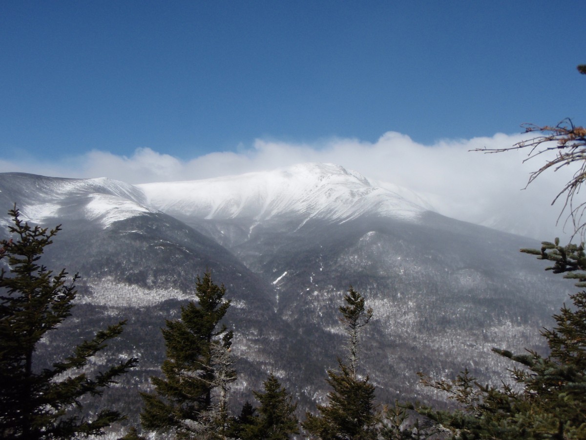
After the nearly 1-mile warmup, the Wildcat Ridge Trail enters (the lower 1/10 mile of this trail is not recommended due to a tricky river crossing), and almost immediately the climbing begins. The 2-mile stretch from here to Wildcat E has 2 very steep sections, with several tricky ledges (a few have steps mounted to the rock slabs). There are some tremendous views to be had from these ledges however, and with clouds quickly lifting off of the presidential peaks, we got to enjoy these views. Only very briefly though, as the temperature was oddly chilly (even sheltered in the trees it felt colder than any other winter hike this year, though it wasn't terribly cold according to the thermometer) and the wind was quite stiff and biting. This stretch of trail, as opposed to my trip through here in January 2012 (where the trail was unbroken powder and very hard work to ascend), was frozen with a crusty surface. Crampons were the order of the day here, though I used Hillsound Trail Crampon Pros (which are an in-between of light traction and full-on crampons) and they were mostly perfect for me. The trail was still steep, but didn't seem quite so bad this time. All of the ledges were fairly simple to climb, including a chimney-like section near the bottom of the trail that last year we had to bushwhack around.
 |
| Somewhat obscured view South down Route 16 |
 |
| Boott Spur (R) and the Gulf of Slides |
 |
| South down Route 16 towards the Pemi |
 |
| Mount Washington's head in the clouds, with Tuckerman and Huntington Ravines |
It was slow, but we made our way without incident to Wildcat E, which used to be on the 4000-footer list until being replaced with Wildcat D, a couple tenths of a mile away on the ridge. Passing through the shallow col between these 2 peaks, we naturally had to stop to take pictures of the skiers getting off the Wildcat chairlifts.
 |
| Wildcat Ski Area's upper chairlift |
 |
| Wildcat chair lift, with Mount Washington in the background |
Once on the ridge, we switched over to snowshoes to keep from post-holing (not only is it uncomfortable, but it can cause a hazard for hikers coming after you if those post-holes freeze into an icy hole). Once completing the short climb from the ski lift to Wildcat D, we stepped out onto the observation platform (most of the steps to it were still buried!), and enjoyed the terrific nearly-360-degree views.
 |
| East towards Maine |
 |
| The Northern Presidentials from Wildcat D |
 |
| HossInNH recording the awesome view of Mount Washington from Wildcat D |
 |
| Mount Washington, Tuckerman Ravine (L) and Huntington Ravine (R) |
The only significant col on the ridge is between Wildcat D and C, and it was a pretty easy snowshoe. On the climb to C, which is somewhat like a stair-step (short, steep sections with flat stretches between), there were some nice partial views of the Wild River Valley as well as the other major peaks in the area. The wind was mostly blocked here, so we could enjoy these views a little more than earlier in the day.
 |
| More Wildcat peaks ahead |
 |
| The Baldfaces from near Wildcat C |
 |
| Doubleheads with Kearsarge North behind |
 |
| Sable (L) and Chandler (R) from near Wildcat C |
Once we reached the treed-in summit of Wildcat A (which is a few yards to the East of the trail proper and in the woods), we dropped down to the viewpoint (marked) nearby to see the stunning views of Carter Notch, and the Carter Notch Hut roughly 1100 feet directly below us.
 |
| The Baldfaces in the distance peeking out from behind Carter Dome (L) |
 |
| Carter Dome from Wildcat A overlook |
 |
| Carter Notch Hut 1100 feet below |
 |
| Closer view of Carter Notch Hut 1100 feet below |
 |
| Wild River Wilderness (South Baldface on far left) |
 |
| The old slide on the side of Carter Dome that formed the ramparts the hut was built near |
From here, the broken trail ended (we only saw a few other hikers to this point, all were doing an out-and-back from Lost Pond Trail...) and we had to break trail down the steep 3/4-mile to the trail junction near the hut. Partway down we met a pair hiking up (in crampons, so the trail they broke out was rather narrow but still they helped some!). There is an old slide shortly before the bottom that the trail traverses. In certain conditions this crossing can be dangerous as the slide leads off a drop and a slide means you will go a ways, but the snow was grippy enough that we had no trouble crossing it. From there, we headed to then hut for a break, before heading out to the waiting car. The exit hike on 19-Mile Brook Trail was uneventful as usual, and before long we were back at Pinkham Notch and parting ways.
And with that, HossInNH was down to a mere 4 peaks left on his New Hampshire 4000-Footer list! Congrats! This hike also brought me almost to 1/2-way on my planned 2013 circuit of the New Hampshire list too. It might be April, but this was one of the more wintry hikes of the year thus far for me!
 |
| Crossing one of the Carter Notch lakes near the hut |
Summary:
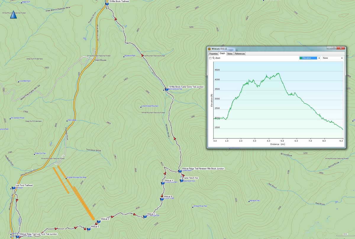
Trails: Lost Pond Trail, Wildcat Ridge Trail, 19-Mile Brook Trail
Peaks: (Wildcat E (4046'), Wildcat D (4062', NH4K), Wildcat C (4298'), Wildcat B (4320'), Wildcat A (4422', NH4K)
Mileage: 9.7 miles
Elevation Gain: 3550ft
Book Time: 6hr 40min (actual 8hr 15min)


No comments:
Post a Comment