Route: Mount Whitney Trail, John Muir Trail Peaks Bagged: Mount Whitney (14,508', highest point in the continental United States) Mileage: ~22 miles Elevation Gain: ~7000’ (varying between 8,300' and 14,508')
This was it, the main event so to speak, of our trip out to California this August. The prior 4 days of acclimation hikes and rests were all just to ensure success on this venture: to summit the highest point in the lower 48 United States. We tore down camp bright and early at Onion Valley Campground, and hi the road for the roughly 1-hour drive down one winding mountain road and then up another 15 miles South. Arriving at the Whitney Portal, we found a very busy parking lot, but found room to park at the main overflow lot just below the trailhead.
We had breakfast right in the parking lot while we finished packing our packs and then putting all extra food, cooking gear, and anything else smellable into the bear lockers in the parking lot (the bears at the Whitney Portal are known to break into a car if they even SEE anything that could be/be holding food, such as a cooler). A short while later, we saddled up and walked a short distance up the road to the trailhead and began the adventure!
Mount Whitney Trailhead
Early views on the trail
Entering the Wilderness!
The trail almost immediately begins with switchbacks, a sign of things to come. Initially, though, the grade is mild, and the footing like most other Western Trails, is smooth, so we were able to get used to the heavy packs (on our way down 2 days later we found a fish scale weighing hook at the trailhead, glad we didn't see that going up!). Knowing we had about 4000 feet of elevation gain to do on the day, we knew the climbing would be starting soon, and sure enough, shortly after crossing the Wilderness Boundary, the grade began to pick up a bit.
Eventually we made our way to Outpost Camp, the "alternative" camping spot to Trail Camp, though it is several mils and several thousand feet of elevation gain from Trail Camp. Here we took a well-deserved break before tackling the steeper terrain to come.
Near the Whitney Zone boundary
Better have a permit past this point
A "Gateway" on the trail
Nearing Outpost Camp
Outpost Camp cascade
Outpost Camp cascade
From Outpost Camp is a steep, but short climb up several switchbacks to Mirror Lake, and a similar steep switchbacky climb to above Mirror Lake, where the tree cover mostly ends. The grade was definitely picking up now, and the footing also started getting less than terrific in spots. Still, it was nothing like what we've encountered on a routine basis in the NorthEast.
Eventually, after a seemingly endless series of short steep climbs up switchbacks, we did make it to Trail Camp, where we were able to secure a terrific spot. It was shielded (mostly) from the wind, near the trail, and also not terribly far from the water. Once finding it, we didn't look any further; we were both tired, so we just set up camp and relaxed for the remainder of the afternoon, doing a little exploring here and there.
Consultation Lake
The Southern Ridge of Mount Whitney - tomorrow's objective
Camping at 12,000ft for the next 2 nights - this old Kelty tent has been to some great spots but this one takes the cake!
After a restless night of sleep accentuated by hearing many hikers coming by early in the morning, including the ones with walkie-talkies blaring at 3AM (not kidding you...), we were up at first light, and getting ready for summit day. The weather forecast was exceptional for the next 2 days, so we were sticking to the original plan to summit today (day 2) and hike out tomorrow (day 3). Still, we wanted an early start just in case of afternoon storms (there hadn't been a drop of rain all week so far mind you).
Sunrise at Trail Camp
Some hikers already well into the switchbacks.
Right from Trail Camp the trail climbs to Trail Crest, at roughly 13,700 feet, using the infamous "97 Switchbacks". In truth, there are indeed 97 switchbacks before Trail Crest, but the grade due to them is mild and the footing mostly good throughout. We came upon the cables section roughly half-way through the switchbacks, where the only ice we would come across on our trip was present alongside the trail (not on it though). The cables section is not what you might think, it is merely a section of trail that was cut out of the rock and has a steel cable set up along one edge as a pseudo-railing.
Leaving Trail Camp (scattered around the right side of the lake)
Cables section of the Mount Whitney Trail
Icicles alongside the trail in the cables section
Eastern pano from high up the switchbacks
Higher up, the switchbacks are often very short, only a dozen or so feet in length. But after these, there are a couple of long switchbacks before the final long traverse up to Trail Crest. There at Trail Crest we got our first look at the Western side of the ridge, and WOW! What a view!
The "other" side of Mount Whitney - the John Muir Trail approach
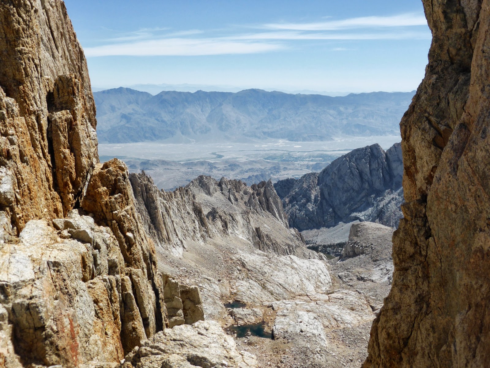
From here the trail drops a couple hundred feet to the junction with the John Muir Trail before beginning a long traverse that gradually climbs, winding among several spires. In this stretch the rubble path to the peak of Mount Muir appears on the right. We had considered hitting this peak on our descent, but after seeing the short cliffs that one needs to ascend above the rubble field to get to the summit (it is said to be a Class 3 climb after all), we decided that peak would remain un-bagged. After that, we soon came to the "windows", which are a series of narrow viewpoints between the spires, looking back to the East towards Trail Camp and the surrounding area.
Looking down into the basin on the Western side of Mount Whitney, past a trailside-campsite on the John Muir Trail
Looking back to where the John Muir Trail comes up to the ridge from the West
One of the "windows"
Another "window"
Yet another "window"
Looking back towards the long traverse we just finished (left side)
After the traverse, which is roughly 2 miles long, the trail swings around the Western side of the summit cone (the Eastern side is a sheer cliff face after all) and climbs up to the summit. The summit itself is fairly broad and flat, with a small summit building on it (most of which is closed to the public, and is not safe to take shelter inside of in the event of a storm). Predictably, the summit was very busy when we got there.
The summit of Mount Whitney - trail swings along to the left
Looking straight down from the summit to Iceberg Lake, the start of many mountaineering routes to the summit
Busy summit
Some climbers getting ready to leave
Pano from the summit
Summit building on Mount Whitney
Mount Whitney summit register
Wide-reaching views!
Sign predates the latest survey, which puts the elevation at 14,508'.
A marmot was hanging out on the summit looking for food - looks like he's found plenty of it over time!
We made it!
We hung out for over an hour on the summit, enjoying the views and snacking, before beginning our descent via the same route back to Trail Camp (there is no other trail there anyway!). The descent, overall, was pretty easy due to the moderate grades, and going down the switchbacks was a blast actually. Back at Trail Camp, we took another short nap, made dinner, and hit the sack at sundown.
Some of the switchbacks we ascended earlier in the day
The backpackers coming up the John Muir Trail mostly left their packs at the junction in order to slack-pack to the summit
Heading down the switchbacks
The next morning, we were up at dawn again, ate and packed up, and hit the trail back to the car. At this point, we had Portal Burgers waiting for us, and later on a real bed and showers at a hotel in Ridgecrest, so there was motivation to keep on moving. The descent of course was fairly steep, as the ascent was, but eventually we made it down to Lone Pine Lake and the easier terrain. From there it was cruise control to the car where we threw in our packs, and then walked back up the road to the Portal Store for a beer and a burger and fries. Yum yum!
Consultation Lake on the way down
We heard a loud crash, and looked over in time to see a couple boulders fall down this cliff well off the side of the trail
Standing sentinel
Mirror Lake
Notes:
- Our acclimation process worked superbly, neither of us had much trouble with the climb, though naturally we needed a few more breathers than normal while climbing
- We saw a lot of day hikers coming down the switchbacks under headlamp. It is a very long dayhike with a lot of elevation gain, even for those who have acclimated to the elevation.
- The terrain and grade was definitely harder than any of the other hikes we did on this trip. There is even a lengthy stretch on the main ridge that reminded us of the Northern Presidentials in New Hampshire. That said, it was still easier than a lot of the Northeast Trails.


Great pictures! what are using for a camera?
ReplyDeleteThanks Dave!
DeleteThe camera is a Panasonic ZS-30 that I picked up a few weeks before this trip. It's my go-to camera now, I've been very happy with it overall.