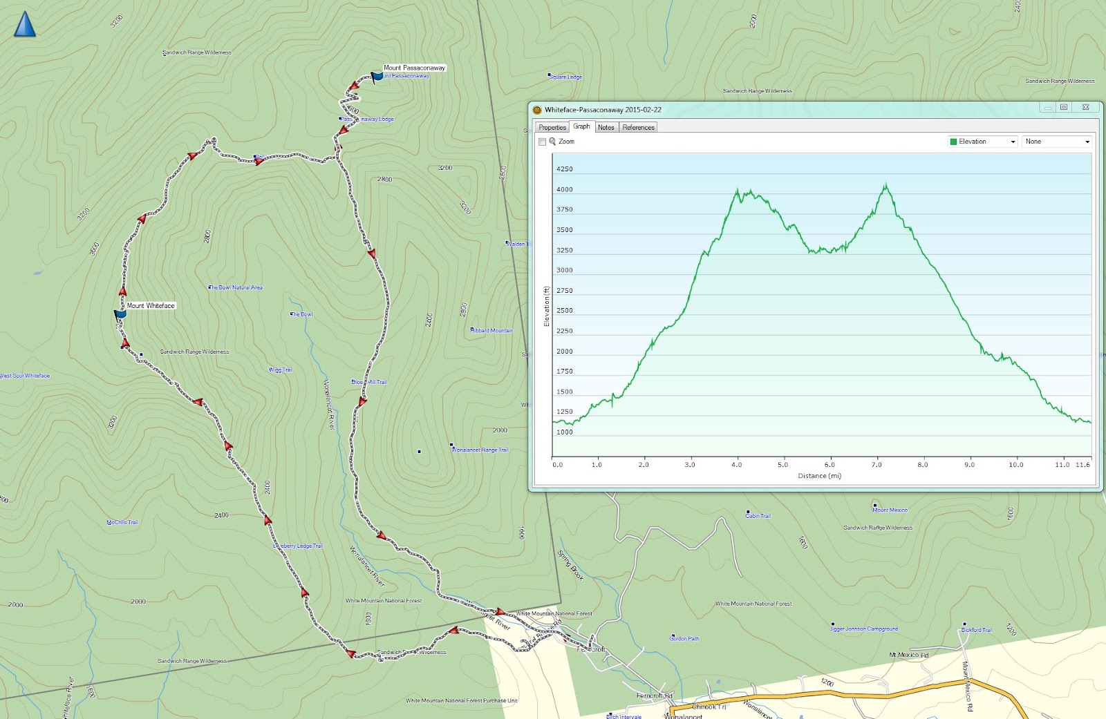
Route: Blueberry Ledge Trail, Rollins Trail, Dicey's Mill Trail
Peaks: Whiteface (4020', NH4K), Passaconaway (4043', NH4K)
Mileage: 11.9 miles
Elevation Gain: 3900'
Book Time: 8hr (actual 8hr 20min)
This was originally going to be a Meetup group of 6, but by the end of the evening before, we were down to 3 due to worries about slippery roads in the morning. It had in fact snowed over 5" overnight in the White Mountains, a nice fluffy fresh coating of snow atop the already great snowshoeing base. The 3 of us remaining all arrived to an un-plowed parking lot at Ferncroft, which wasn't anticipated but also was not unexpected given it was still early on a Sunday morning. Luckily we all made it down the access road off of Ferncroft Road just fine, and geared up to head out. This was to be yet another car-to-car snowshoe hike.
 |
| Early morning at Ferncroft, my favorite trailhead in the White Mountains |
 |
| A little bit of blue sky peeking out at the trailhead. |
 |
| The Wonalancet Range in the morning. |
There had been a bunch of people hiking these two peaks the day before, but with 5" of new snow and a fair bit of wind overnight, we had some work to do ahead. After initially taking a wrong turn down someone's driveway (somehow we missed an obvious arrow on a tree...), we set out on the proper trail and began the ascent. The Blueberry Ledge Trail starts off pretty mildly, only gradually gaining elevation for a while before steadily but still not steeply climbing to a junction on some flat, semi-open ledges at the upper junction with the Blueberry Ledge Cutoff (which interestingly looked to be well-broken out at the lower junction). To this point we had mostly had a clear snowshoe trench to follow, just needing to break out the new 5" of fluffy snow, and the occasional drift to content with in open areas.
 |
| Starting off on a freshly-snowed-on but easy-to-follow trail. |
 |
| There's a LOT of snow in the mountains right now. This was easily 3 feet of snow on top of this massive trailside boulder. |
 |
| Limited views from the Blueberry Ledge/Blueberry Ledge Cutoff Junction |
It was a surprisingly warm morning, probably the warmest day of the winter thus far, with temps in the low 20s already. And after a break at the junction, the real work began. The Blueberry Ledge Trail begins to climb fairly steeply at times from here to the base of a series of ledges. The ledges are the crux of this trail. In summer, they can be a bit tricky to ascend particularly if wet. My only prior winter visit had seen them well-packed out and fairly easy to snowshoe up. This day made up for that. All prior trace of traffic had completely drifted in, and we had great difficulty getting up the ledges. An attempt to climb uphill often resulted in the snow beneath the snowshoes sliding back down hill. We were literally swimming up in several feet of loose powder, but eventually the 3 of us did get up the first 2 ledges, which were the toughest. Above there are several more ledges, but less steep and so we had an easier go of it. Too bad the clouds had rolled in and we had no views from these ledges, which offer some terrific views on clear days.
 |
| Swimming up the second ledge - the spot the hiker is in was the toughest of the day, we each needed multiple attempts to get up the deep, loose snow there. |
Once reaching the upper-most ledge, which many folks mistake for the actual summit of Whiteface, we descended a short ways and then climbed up to the actual, completely wooded summit. Actually, we walked right past the summit before realizing we had passed it an so turned around and went back to the top for a few pictures and a good snack break. It was still pretty warm up top!
The Rollins Trail just past the summit completely disappeared. The woods were fairly open in one stretch and the old trench had completely filled back in and it took a few tries to find the proper corridor (my GPS track of the trail was a useful aid in this exercise too). For the first 3/4-mile or so we occaisonally had to figure out where the corridor went, and in between we could sometimes see evidence of the old snowshoe trench. Still, we actually had little trouble aside from that first spot, and once getting down off the bulk of the descent we had a pretty clear old trench to follow the rest of the way to the junction with the Dicey's Mill Trail. In here is when Heather and her dog Kali, Alton and her dog Cole, and their friend Jason (?) caught up to us. These speedy hikers had started nearly 2 hours after us and caught us already!
 |
| A view of Passaconaway from the Rollins Trail near Whiteface. |
The final push to Passaconaway from this junction is always rough, as the trail initially switchbacks a couple times before heading straight up the summit cone to a sign pointing to the (un-marked) summit in a clearing in the woods. Just below the summit there is a nice outlook towards the Tripyramids where we had good views today as the clouds had cleared and the sun come out. We enjoyed a few minutes here before heading off down the trail. We had a nice speedy descent on a well-packed trail thanks to a bunch of traffic that had just visited Passaconaway on this day, and we were back to the trailhead before 5, ready for the long drive home.
 |
| The Tripyramids from just below Passaconaway |
 |
| Mount Carrigain and Carrigain Notch |
 |
| Mt. Hedgehog (?) from Ferncroft in the late afternoon |
 |
| Heading back to the cars. |
 |
| The ledges atop Mount Whiteface, which we had to climb earlier in the morning. |
 |
| Such a scenic place, Ferncroft is. |


No comments:
Post a Comment