Date of Hike: July 31 - August 1, 2015
Route: Valley Way, Brookside, Lower Bruin, Osgood Trail, Gulfside, Lowe's Path, Jefferson Loop, Clay Loop, Trinity Heights Connector, Crawford Path, Monroe Loop, Franklin Loop, Eisenhower Loop, Webster Cliff Trail, Crawford Path
Peaks: Madison (5367', NH4K), Adams (5774', NH4K), Jefferson (5712', NH4K), Clay (5533', TW72), Washington (6288', NH4K), Monroe (5372', NH4K), Little Monroe (5200'), Franklin (5001', TW72), Eisenhower (4780', NH4K), Pierce (4310', NH4K)
Mileage: 20.7 miles
Elevation Gain: 9000'
Book Time: 14hr 50min (actual 16hr 15min)
I've been doing a lot of longer hikes this year, usually between 15 and 20 miles, and frequently 6000 feet or more of elevation gain. That has been for a reason: I decided to finally do my first Presi Traverse after years of saying I wouldn't, and wanted to work up to it and not feel completely dead/zombie-like at the end. Scheduling conflicts pushed it back to August 1, instead of sometime in July as originally planned, but such is life. The weekend weather for most of July wasn't conducive for this kind of hike anyway.
But I've also long wanted to do a full moon night hike of something (I've always figured Franconia Ridge or maybe the Southern Presis). The full moon seems to never coincide with a weekend, nor a weekend where the moon is up at night. Nor do the skies ever seem to be clear for such events. Well, Friday morning (July 31) saw a full moon, meaning it would be close to full the next time it rose. It was due to rise Friday at 8:08PM, and stay up until 6:58AM Saturday morning, with sunset being at 8:12PM Friday and sunrise at 5:32AM Saturday. In other words, the moon was going to be up when the sun wasn't. The wheels got turning on making the first Presi Traverse something even more epic: yes, hike our first Presidential Traverse, but do it at NIGHT, under a full moon! The weather forecasts for the week leading up all pointed to almost completely clear skies, with the exception of the Mt. Washington Observatory's forecast, which called for socked-in summits and even some rain throughout the night. I decided to listed to the other forecasts, and mostly ignore the OBS one, especially when skies cleared Friday afternoon as the "other" forecasts were all predicting. The only bummer heading into this was the late cancellation by one of our planned party, nursing a sore knee. But my friend Theresa and I were still going for this!
 |
| Yes, this is our start time! |
 |
| The Brookside closely follows the stream and there are a few nice cascades. |
 |
| Salmacis Fall |
 |
| Alpenglow on Madison as we near the hut. |
 |
| Madison Hut below J.Q. Adams |
We set out from Valley Way at 5:30PM, and did a little minor red-lining on the way to the hut, checking off the Brookside and Lower Bruin trails (no, we cannot help ourselves, plus the Valley Way is boring, especially after so many hikes on its length). We reached the AMC's Madison Springs Hut in time for the last bits of the sunset from the lower flanks of Madison. The skies were essentially clear at this point, with just a few clouds lingering here and there. It was rather windy on the summit, though only on the summit area thankfully, so we didn't hang too long. As we put on headlamps to leave the summit, a group of 4 young guys (am I allowed to say that?) arrived, with the same plan as us. We filled up water at the hut and took a lengthy break, leaving as they were about to turn off the lights inside (9:30PM for reference) before stepping out into the darkness to tackle the Northern Presis under moonlight.
 |
| Moon's risen, right on schedule! |
 |
| That's no (full) moon... |
 |
| Washington (L) and Adams (R) - we'll be there later. |
 |
| Final rays of sunlight behind Mt. Adams. |
 |
| Gorham and Berlin from Madison. |
 |
| Headlamps on, leaving Madison. |
The trek through the Northerns, put simply, was amazing. I don't really know how else to describe or convey it, and I'm not nearly a good enough photographer to even attempt to capture it (though I did get a few pretty cool shots). We ran into 2 more solo hikers on/around Mt. Adams also out for the full moon traverse (making 8 of us doing it!), one of whom hiked with us as far as the Clay Loop before taking off at his more aggressive pace (and the other 5 were long ahead of us at that point). Much of the hike from the Jefferson Loop down to Sphinx Col and the Clay Loop was done 100% under moonlight, as the moon was high enough and bright enough to switch off the headlamps. Midnight passed as we took a break near Edmand's Col, and clouds started to build as we climbed Clay and then Washington. Washington was very windy (low 40s mph with likely higher gusts), and was also cloudy (though we could still see lights in the valley, so we were just barely below the cloud level). Not surprisingly, but for reference, the summit buildings are closed at night, and even the breezeway entry is shuttered shut. The skies cleared a fair bit as we descended to Lakes of the Clouds Hut.
 |
| It's a little windy, but here we go! |
 |
| The Gorham-Berlin stretch all lit up from Thunderstorm Junction. |
 |
| The moon behind Mt. Adams, our next destination. |
 |
| Atop Mt. Adams. Yes, it's windy. |
 |
| I found the mode on my camera where I could set a 30s shutter. This was the first result, hand braced against a rock. |
 |
| Tripod 30s shot of Mt. Washington, right around midnight. |
 |
| A lone headlamp heading up to Mt. Jefferson. |
 |
| Washington
from Sphinx Col, at 1:30AM. The moon is bright, and a few times in the
next hour we'd hike without headlamps, the trail lit only by moonlight. |
 |
| Some lenticular clouds are rolling in. |
 |
| Some more clouds are rolling in as we approach Clay. |
 |
| Mt.
Washington. No line at the top at 3AM! It's also very windy, in the low
40s mph, thankfully not windy once off the summit. The skies have also
clouded up a lot, but the summit is just barely below them and we can see lights in the valley. |
 |
| Mt. Monroe is up next, once we get to Lakes of the Clouds and refill on water. |
We filled up water again in the hut (taking care not to trip over a thru-hiker sleeping in half of the pathway to the water spigot and bathrooms...), and set off for the Southern Presis as the skies lightened. Off went the headlamps. With clouds filling in again, the sunrise was actually very cool, and while the sun itself was behind Boott Spur, the light on the clouds was spectacular. Pinks, reds, oranges, it was all there; the sky was on fire! But by now we were ready to be done (and take a nap - after all we'd been up since 6 or 7 am the day before!), so the best we could we moved through the Southern Presis. A few darker (non-thunderhead) clouds spit a little rain on us between Eisenhower and Pierce, but that too cleared out quickly. Everything was good (though there was no way we were going to do anymore climbing!) until that 3.1-mile descent down the Crawford Path, which seemed to get longer and longer. Finally, at 9:45 we reached the car, headed off to get a good breakfast, then headed back to Appalachia where the other car was. I took a good nap in the car before driving home after a truly epic, bucket-list-busting hike!
 |
| First light as we leave Lakes of the Clouds Hut shortly before 5AM. |
 |
| I loved seeing the string of cairns on the Davis Path backlit by the sunrise like this. |
 |
| Little
Monroe and the Southern Presis from Mt. Monroe. It is 5:07am. The
clouds, which had thinned out as we left Washington, are thickening
again to the West. |
 |
| Red skies in the morning, sailors (and hikers!) take warning. |
 |
| Franklin, Eisenhower, then Pierce and we can head down. |
 |
| Mt. Eisenhower. |
 |
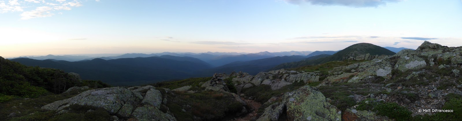
| Pano from Mt. Franklin. |
 |
| The Pemi behind Webster and Jackson. Carrigain on the left, and the Bonds in the center. |
 |
| Washington is in a cloud. What else is new? |
 |
| Heading to Pierce, the last summit of the hike. Is it nap time yet? |
 |
| Leaving Pierce for the "long" hike down. |