Yea, okay, kinda corny line. I had originally planned to spend a week in Maine later this month with a friend of mine hiking the 10 4000-footers in the Rangeley-Stratton area of Maine. The Appalachian Trail runs over all of these save one, which doesn't actually have an official trail to it at all. However, the access to the trails for some of the peaks is best reached via a rather rough, unmaintained logging road with numerous decaying bridges. My friend has a Jeep, I have a low-clearance car. Need I explain that more? But we changed plans, with my friend understandably not really wanting to drive roughly 11 hours each way.
Almost simultaneously a Meetup Group that I joined a couple months back (mainly so I wasn't always hiking alone this coming winter) posted a pair of weekends to bag these 10 peaks. It means 2 separate 4.5-hour one-way trips up there, but it also means limited time needed to be taken off from work (basically just leaving early on the 2 Fridays). This weekend was weekend #1, and the Saturday hike was to the Bigelow Range.
There are 2 peaks rising over 4000 feet on this ridge, which rises high above man-made Flagstaff Lake at the Northern end of the Rangeley-Stratton region. These 2 peaks are a mere 0.7 miles apart, named Avery Peak (4088') and West Peak (4145'). One thing to note about the 14 Maine 4000-footers: none save the 2 major peaks of Katahdin rise very far over 4000 feet. In the case of the Bigelows, the summits are exposed, but the ridge is mostly treed-in.
A straight-forward approach is available to the 2 Bigelow peaks: the Fire Warden's Trail from the South leads right to the col between the 2 peaks, moderate in grade for most of it's 4.7 miles, but the last mile gains around 1300 feet in elevation. The footing is very good the entire way, however, with rock stairs in the steeps. A couple miles down the ridge from West Peak, however, there is a peak on the New England 100-Highest list, a list I am somewhat pursuing. This peak is called South Horn (3805') and has a twin just to its North called North Horn (shocker!) - 3792'. And just a little further down the ridge is Horns Pond, a nice pond with campsite near its shore, and a trail that cuts right back to the Fire Warden's Trail about 2 miles from its start. This was a loop I wanted to do, and lucky for me, the trip leader had planned for this loop as well.
 |
| The route |
3 of us started out at the somewhat leisurely hour of 8:25. In addition to myself and the trip leader Chris, Pam from Hike-NH was along for the trip. It was great to finally get to hike with Pam after crossing paths a couple times on the trails this year.
The trail initially follows the road that the parking lot is on a bit further to Stratton Brook Pond, and people with good clearance vehicles could actually make it the extra 1/2 mile or so to the pond and save some walking. It crosses the wide outlet of the pond, which was an easy rock hop, and enters the woods. Aside from a few peeks through the trees to the col we were heading to, there isn't much to see other than a nice woods walk until you hit the col. From the col we turned East, and scrambled up some rough footing to the summit area. The foundation of an old fire tower is just past the summit, along with some broken glass and a few charred remains of it that were not removed from the summit.
 |
| Sugarloaf from Stratton Brook Pond |
 |
| Fire Warden's Trail heads to that col - Avery Peak right, West left |
 |
| West Peak as we headed up Avery Peak |
 |
| Final push to Avery Peak |
 |
| Rather faded summit sign |
While the Maine Guidebook mentions a spectacular view at Avery Peak, one really needs to be there to understand how magnificent the 360 views are.
 |
| West Peak from Avery Peak |
 |
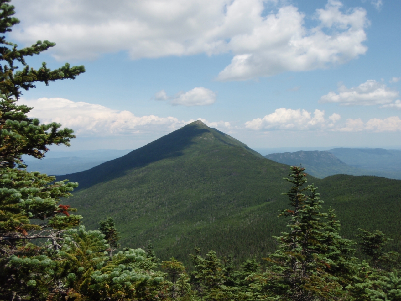
| Little Bigelow Mountain |
We hung out below the summit (out of the pretty stiff winds whipping around) and ate some lunch. It was 11:20. A long break at the summit, then we packed up and headed back to the col, where Chris retrieved a water bottle he left there, and then on to West Peak.
 |
| Heading back to the col, then West Peak |
What the guidebook fails to mention is that West Peak has extremely good views as well.
 |
| Avery Peak from West Peak |
 |
| The Horns |
 |
| White blazes to The Horns |
 |
| Avery Peak with Little Bigelow in the background |
 |
| Chris heads off to the Horns |
 |
| The Horns |
 |
| The Horns |
After a little break at this summit, we began the long trek to The Horns, roughly 2.3 miles to South Horn, still along the Appalachian Trail. The initial descent off West Peak, as can seen above, has a nice above-treeline trek. It soon drops into the trees, and is a long, gentle downhill followed by a gentle climb with a brief scramble to South Horn. South Horn has nice Southern and Eastern views from a ledge at the summit.
 |
| Looking back at West Peak |
 |
| West Peak |
 |
| The ridge from West Peak |
 |
| Further West along the Bigelow Range |
 |
| Horns Pond |
 |
| Horns Pond |
 |
| Check off another NE Hundred Highest! |
From here, it is a short 0.3 miles to North Horn, which does not quite make the 200-foot col requirement to be a NEHH peak, but we visited anyway. It turned out to have better views (360 degrees) than South Horn anyway. And it was actually only a 0.2-mile each way detour as the AT goes 1/10 mile towards North Horn before dropping to the pond.
 |
| Sugarloaf from South Horn |
 |
| South Horn from North Horn |
 |
| The ridge towards West Peak |
 |
| Ridge from West Peak to South Horn |
 |
| Horns Pond - next stop |
From North Horn we cut back to the AT and dropped to Horns Pond, where we took a break and topped up on water while relaxing by the pond (and someone took a swim...). It had been a warm day and both Pam and I were down to about 1/2 liter from our starting 3L. We were likely fine as it was all descent, but it's better to be safe than sorry. Chris somehow declined despite only bringing 2L with him. He would run out about 1 mile from the car, so not too bad.
 |
| Full "box spring" right along the trail just before hitting Horns Pond campsite. The campsite has a separate water source. |
One interesting thing about Horns Pond Campsite: it has a caretaker during the summer, but is still a no-fee site! The pond was very nice and the site looked like a great place to spend a night, but we were on a dayhike, so eventually we headed down. The descent dragged on, but we reached the car at 5:20, not quite 9 hours from the start.
The weather forecast for the day had been for rain and scattered thunderstorms, but as can be seen, we lucked out with lots of blue sky, even if it was a little hazy. It was warm too, but not massively so. Really, it was hard to complain about anything on this day. What an amazing entry hike into the Maine 4000-footers!
Summary:
Peaks: Bigelow Avery Peak (4088', NE4K), Bigelow West Peak (4145', NE4K), South Horn (3805', NEHH), North Horn (3792')
Mileage: 13.8 miles
Elevation Gain: ~3900'
Total Time: 8hr 55min including breaks


What an awesome and productive weekend Matt. The Bigelow's look fantastic. I'll be hitting them someday. For me, it's that damn drive from Mass.:(
ReplyDeleteJoe
Definitely find a weekend or longer and do the drive Joe. Completely worth it, around 4 hours from you. Don't make someday too long now ;)
ReplyDeleteHi Matt, I've been looking for a mountain photo to use for the report of a non-profit; okay to use one of your shots?
ReplyDeleteDrop me a line at mad_matt_d_2001_AT_gmail_DOT_com (remove all underscores) and we can discuss.
Delete