It was time for the second scheduled weekend in Maine for peak-bagging in the Rangeley-Stratton area. First up was easily the longest dayhike of the 4 in this area. There are no loop options (at least along maintained trails) for the three high peaks on the East side of the Caribou Valley Road, and so most people looking to do Sugarloaf, Spaulding AND Abraham all in one dayhike do an out-and-back from the CVR along the Appalachian Trail and the Abraham Side Trail. This hike entails roughly 17.4 miles and 6000 feet of elevation gain, with a very steep section near the CVR. With the CVR closed 1/2 mile from the AT still, it meant a hike of a little over 18 miles!
A car-spot was discussed briefly for coming out over Mount Abraham on the Fire Warden's Trail, but that was going to be a really tough, out-of-the-way car spot, so that was abandoned. In planning this trip, Chris, the organizer once again, asked me to look into possible herd paths/bushwhacks down from Abraham to the CVR. This wouldn't save us much of anything in mileage, but it would save around 1500 feet of climbing on the way back, and the last several miles would be all along the washed-out, but easily-walked stretches of the CVR. With a little research and some Google Earth imagery, I constructed a couple of GPS traces of some logging cuts I saw there that we could try to navigate to to get down easily.
This time around there would be three of us for both hikes, as a gentleman named Will who had recently finished the NH 4000-footers and was now wanting to work on the New England 100 Highest joined us. It was a slow trip out of Massachusetts on that Friday night as there were tons of accidents, but we eventually rolled into Rangeley around 9PM.
Then we had to GET to the trail. While
2 weeks previously we found the Caribou Valley Road in decent shape up to the steel bridge, this time we found a different story. The lower 3 miles of the road had been covered in a thick layer of dirt, presumably to fill in holes and such, but it had become very rutted and washboarded, making for a much rougher ride than we had our last visit here. The last 0.9 miles to the parking area was just what we remembered, nothing that taking it slow couldn't handle.
A quick saddle up, and off we went on the CVR, and then a hard left onto the barely-noticable Appalachian Trail. We quickly crossed the Caribassett River, which was an easy rock-hop combined with a 2x10 board strapped to a pair of rocks. Then the grade soon steepened, with us passing over a scree slide a couple of times. There were some nice views across the valley though, which made for nice excuses to rest.
 |
| South and North Crocker |
 |
| Redington trying to hide behind the shoulder of South Crocker |
After a while, the grade moderates, and then runs nearly flat for a while until the Sugarloaf Side Trail diverges 0.6 miles to the open, rocky summit of Sugarloaf, the second-highest mountain in Maine (behind Katahdin of course).
 |
| Crockers and Redington |
 |
| Saddleback and the Horn |
 |
| Bigelow Range |
 |
| Abraham (left-center) and Spaulding (right-center), the next stops |
Sugarloaf is of course a well-known ski area in the North-east, and the slopes come nearly to the top, with numerous buildings scattered around the summit. Here we took a break before executing an about-face and heading back to the AT, and then on to Spaulding.
 |
| Dedication plaque between Sugarloaf and Spaulding |
 |
| Spaulding has a new summit sign, but is listed at 4000 feet everywhere else... |
After taking the short side trail to Spaulding's nearly view-less summit, we headed down to the Spaulding-Abraham col, where there is the Spaulding Mtn. Lean-to.
 |
| Fire pit at Spaulding Mtn. Lean-to |
 |
| The Spaulding lean-to - yup, it was sunny out! Thru-hiker (North-bound) hanging out inside |
We took a longish break here, spending a while chatting with a North-bound thru-hiker who was nearing the end of his journey. He is probably nearing Katahdin at this point, if he hasn't finished already. It is amazing just how many North-bound thru hikers we saw in our 2 weekends in Maine, July is very early for this many to be that far North, but the mild winter seemed to allow many to get an earlier-than-normal start.
From here we had a short distance more to drop to the col, where we saw a well-defined herd path heading towards the Caribou Valley (where the CVR is), and was very close to one of the traced logging cut routes we had identified as a route down. We decided this would be our way back down to the car (more on that later).
From here we began a brief climb to the Abraham Side Trail (Mount Abraham Trail), which diverges from the AT and goes right over the rocky summit of Mount Abraham. It travels over several false summits along the way, and crosses a couple of scree fields before attaining the summit. Many people have mentioned how Abraham is much like one of the Northern Presidentials in New Hampshire (in particular Mount Adams) and aside from the much lower elevation, it does indeed have that feel.
 |
| Views from Mount Abraham Trail |
 |
| Mount Abraham from one of the scree fields |
 |
| Cresting the first false summit on a scree field |
 |
| Closer to Mount Abraham... |
 |
| Spaulding (foreground) and Sugarloaf (center, distance) from Mount Abraham |
 |
| Second, slightly-lower summit of Mount Abraham (has the carin oddly) |
 |
| Roof of a shelter at the Abraham summit |
 |
| Small entrance to the rock shelter on Abraham |
 |
| South Crocker and Redington from Abraham (I think) |
 |
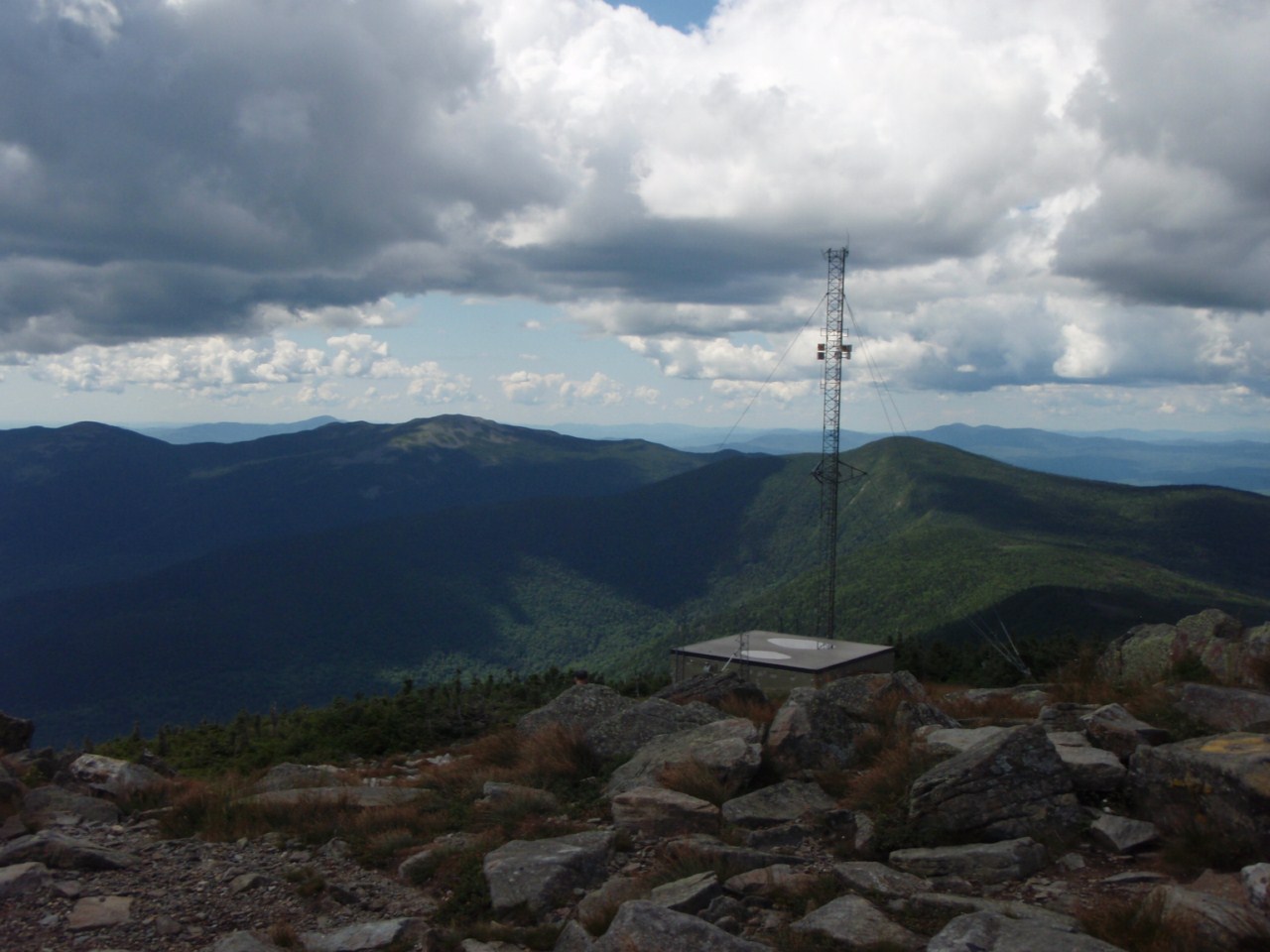
| Tower remnants on the summit of Mount Abraham |
Here we took a long snack break, enjoying the 360-degree views and the end of our intended climbing for the day (aside from the short ups on the Abraham Side Trail going back of course). We were a mere ~10 miles into our journey to this point! We eventually headed back to the AT.
 |
| Heading back down on the Abraham Side Trail |
 |
| Some sort of old trail at the Abraham/Appalachian Trail junction |
Back at the Appalachian Trail, we briefly discussed taking a wide, unmarked trail that left the AT across from the Abraham Side Trail. We knew there was a series of logging roads not too far down that eventually let to the CVR, but not before taking a significant detour South, the opposite direction from our car (Later, I discovered Google Earth was showing me old imagery despite having new imagery, and I found clear cuts and some roads roughly 3/10 mile from this intersection that would not go too far astray in getting to the CVR. It might be a very good option for getting down, next time here I intend to try it.) Thus, we opted to go back to the other herd path we had seen near the Spaulding lean-to, and headed there.
The herd path was easily followed for a while, though certainly not as defined as a real trail. It led through wide open woods to the crest of the ridgeline, after which it soon petered out. From here we cut towards what looked like a logging cut on Google Earth, hitting some thicker woods here and there. We crossed an AT boundary cut, which is a cleared swath that parallels the Appalachian Trail roughly 1000 feet on either side of it, marking the AT property. After crossing this, we soon cut to the swath on the imagery, finding not an old road or AT trail like we hoped, but a band of thick spruce. Not sure how that happened to be a cut on the satellite...
So we just decided to meander our way downhill, through whatever open woods we could find, hoping to hit another logging landing roughly half-way down. We hit the AT boundary cut again as we traversed above the spruce field trying to find better woods, then we went down. The woods progressively got worse, with abundant amounts of thick, dead branches. We took whatever relatively clear spots we could find, including skirting some boggy areas. While trying to cut over to the logging landing, the woods would not have any of it, so we just kept heading to the road. After a really long time (roughly 1hr 20min), we hit the CVR, a mere couple of tenths of a mile from the bridge over the Caribou Pond outlet where the road down from Redington comes out. We made quick work of the 3-mile road walk back to the car.
Aside from the bushwhack that didn't quite go to plan, it was a great hike, with some great views from Sugarloaf and Abraham.
 |
| Google Earth overlay of the track hiked, Abraham is the rocky peak on bottom-right |
Summary:
Peaks: Sugarloaf (4240', NE4K), Spaulding (4000', NE4K), Abraham (4040', NE4K)
Mileage: ~17 miles
Elevation Gain: ~4400 feet


No comments:
Post a Comment