Katahdin. The goal of so many a thru-hiker, the Northern terminus of the Appalachian Trail. The ultimate peak in the Northeast, completely different from anything else. It has more of a Rocky Mountain feel to it, with its high, exposed, narrow ridge known merely as the Knife Edge, steep cliff faces, and rock slides galore. it is also the highest point in the state of Maine, at over 5200 feet, in a state where no other peak exceeds 4300 feet, in an area almost completely flat except for a small cluster of mountains.
 |
| Mount Katahdin |
My father wanted to come with me whenever I tackled this peak, and in April we decided to go for it. Camping reservations in Baxter State Park, where Katahdin is located, are hard to get, especially for Chimney Pond, the campground right at the base of the Katahdin basin. 4 months out from your arrival date you can request reservations, and we were already at 3.5 months until the end of summer, but we were able to secure 2 nights at this campground, and then 2 more nights at Nesowadnehunk Field Campground, on the other side of the park. The latter would allow us to tackle North Brother, the other 4000-footer in Baxter State Park (there are 2 peaks of Katahdin that are on this list), along with some other peaks in the area. But Katahdin was our focus.
Baxter State Park is a park set up to keep everything primitive inside of it, per the requests of Percival Baxter, the former governor of Maine who helped buy and donate land that now forms the majority of the park. There is no electricity within the park aside from some solar panels, and the roads are winding, narrow dirt roads where the speed limit is 20mph and it is hard to do much faster anyway. It is roughly 6.5 hours to the South Entrance from Boston, MA.
We were to spend Monday and Tuesday (8-27 and 2-28) at Chimney Pond, and the following nights at Nesowadnehunk, which would give us up to 3 days to try to summit, though the goal was to summit on Tuesday. Unfortunately, as the week approached, Tuesday's forecast turned out to be terrible, with 100% chance of rain forecast and some chance of thunderstorms. Wednesday was scheduled to be perfect though, so we just decided to hike in as planned Monday afternoon, perhaps make a try at Hamlin peak, the other 4000-foot peak on Katahdin (Baxter peak is the high point and the summit that the Appalachian Trail starts/ends on) on Tuesday if the weather cleared, and then summit on Wednesday morning before hiking back to the car in the afternoon.
We arrived at Roaring Brook, the trailhead for hiking into Chimney Pond (a non-road accessible campsite) and were on trail at 3PM, well in advance of the 5PM cutoff (Baxter Park has a lot of rules, most intended to keep you safe and the park pristine, check out their
website before planning a trip). The 3.3-mile hike in is moderate in grade, though with a few spots of rough footing.
 |
| Bridge maintenance supplies by a bridge |
 |
| Even shingles! They wrap the top of the main beams of the bridges in these, presumably to prevent excess decay |
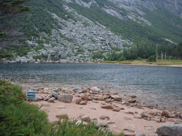 |
| Chimney Pond |
Chimney Pond is a wonderful spot, an alpine lake at the base of the headwall of Mount Katahdin. The campground is scattered around the area, with a covered pavilion, a ranger station, a 10-person bunkhouse (2 separate 5-person bunkrooms and a common area, this was where we spent the 2 nights), and 9 lean-tos (up to 4 people each).
 |
| Part of Katahdin's Knife Edge far above |
 |
| Katahdin's Knife Edge in the fog Tuesday morning |
 |
| Hamlin Ridge, the ridge coming down from Hamlin Peak |
We woke up Tuesday morning, having heard rain off-and-on all night, to fairly clear skies, but that quickly changed. We waited it out in the morning, and around 11AM it looked like things were improving. At 11:30 we hit the trail for Hamlin Peak. We took the Saddle Trail to the col between Baxter and Hamlin Peaks, and then the Northwest Basin Trail to the Hamlin Ridge Trail to the summit of Hamlin Peak. We got poured on for about 10 minutes before hitting the slide near the top of the Saddle Trail, and sprinkled on briefly near the bottom of Hamlin Ridge Trail, but otherwise stayed dry. Unfortunately, once we hit the ridge, we were in the fog until a little into the descent of Hamlin Ridge. I am sure there are great views up there normally.
 |
| Saddle Trail goes up the slide on the right |
 |
| Another slide on the side of Hamlin Peak |
 |
| Towards the end of Hamlin Ridge |
 |
| Turner Mountain in the fog |
 |
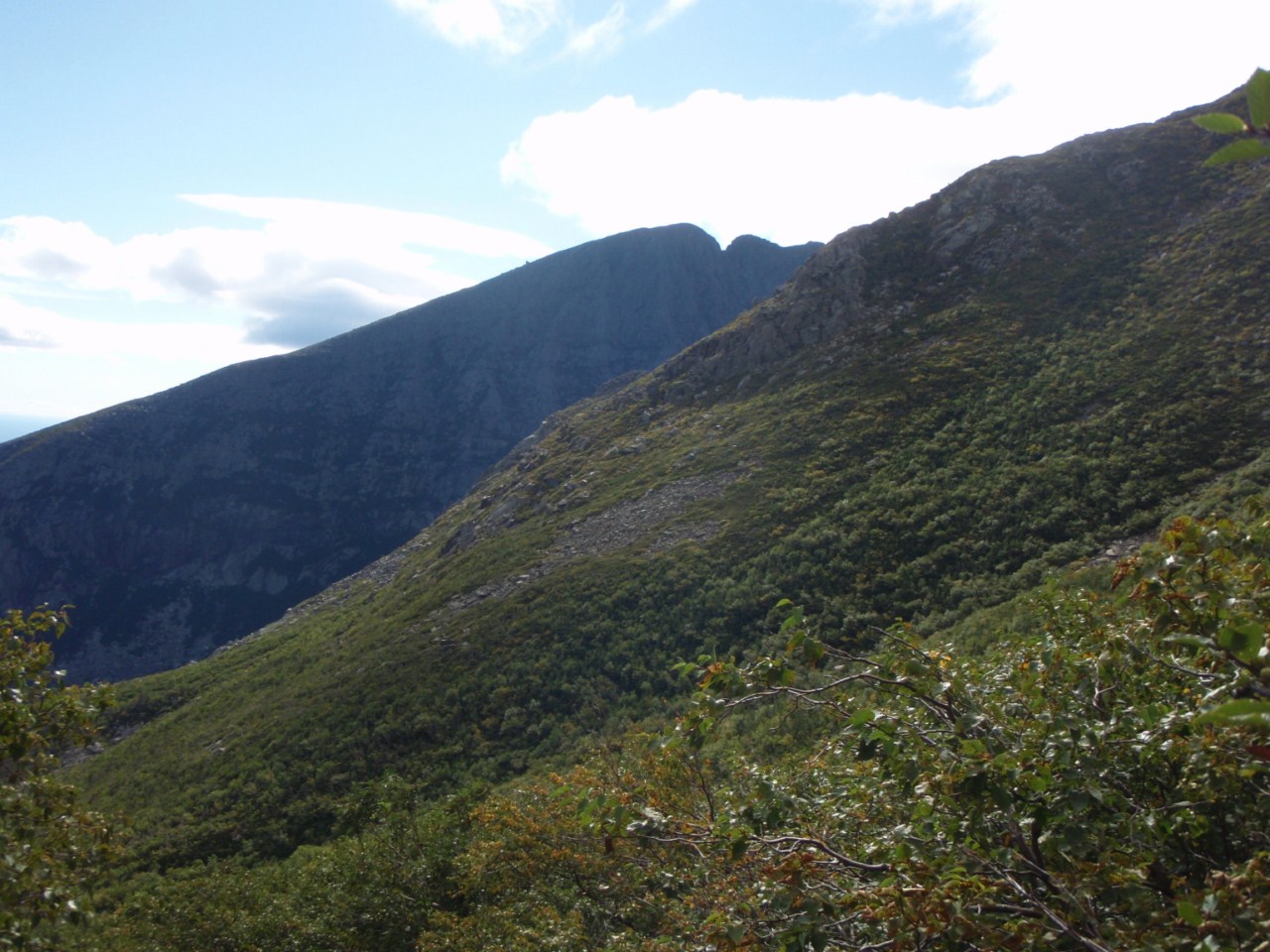
| The Cathedral Trail goes up this ridge - supposed to be VERY steep and scrambly in spots |
 |
| Dudley Trail heads up this ridge to the Knife Edge - hoped to go up this the next day to get to Baxter Peak |
 |
| Climbing Saddle Slide |
 |
| High up on the Saddle Trail - Chimney Pond far below |
 |
| No shortages of blazes on this trail |
 |
| Blueberries on the ridge! |
 |
| Hamlin Peak summit |
We ran into the only people we saw on the trail all day on Hamlin Peak, a group of 4 who soon motored ahead of us down Hamlin Ridge. The ascent from the saddle (col between the main Katahdin peaks) was mild and had only a short stretch of boulder-hopping. Lots of alpine blueberries along the trail, and they were ripe and tasty! It was foggy and windy on the summit, so we didn't linger, but began heading down the Hamlin Ridge Trail. This trail is supposed to be spectacular, and as we got below the fog, we quickly saw why. Unfortunately, nowhere had we seen mention of how rough the footing is. On any other mountain, this ridge would be called a knife edge, but on Katahdin it is nothing special I guess. Lots of boulder hopping later, we dragged ourselves into camp, taking about 5.5 hours to do about 4.5 miles on the trail (ascent and descent!). The views truly were awesome though.
 |
| First views down Hamlin Ridge |
 |
| Chimney Pond far below |
 |
| Hamlin Ridge |
 |
| North Basin - no trails go there |
 |
| Boulder hopping time |
 |
| Looks like a knife edge to me, but it isn't THE Knife Edge |
 |
| Can't see the main knife edge anymore! |
 |
| North Basin - no trails in there, Turner Mountain in background |
 |
| Awesome views coming down Hamlin Ridge |
 |
| Fog slightly lifting off the Katahdin Knife Edge |
We made it back to camp and had dinner. The next day we hoped to go up the Dudley Trail (allegedly a boulder hop for most of its length) and across the Knife Edge to Baxter Peak before descending via the Saddle Trail, where we would grab our overnight gear and hike out to the car. The next morning woke with far clearer skies, but stiff winds all the way down at Chimney Pond, elevation ~3000 feet. With the winds in the 20s mph range down there, we knew it would be far worse up top, and hiking along the Knife Edge, often only a few feet wide at times, was not going to be a great idea. So we resigned ourselves to just going up and down the Saddle Trail. At least we'd get some nice views this time, right?
 |
| Hey, Knife Edge is clear today! (And windy...) |
 |
| Too bad it's just too windy for our comfort |
 |
| Some day? |
 |
| View towards Hamlin Peak |
 |
| Hamlin Ridge |
 |
| Alright, back to Saddle Slide |
 |
| Looks nice, but what's with the cloud? |
 |
| Hmm, looks like it might try to fog in |
 |
| Cathedral Ridge with Knife Edge behind |
 |
| Saddle is right there |
 |
| Looks good that way |
 |
| Real Nice to the East |
 |
| The Chimney |
 |
| View East from Saddle Slide |
 |
| Climbing the Saddle Slide again |
 |
| Hey, blue skies at the saddle! |
 |
| Summit of Katahdin is above that knob, in that cloud... |
As soon as we crested the Saddle, we got blasted with wind. We had pretty good views, though there was a cloud sitting on the peak we were going to of course. With the cooler temperatures today, along with 30s mph winds, we were both somewhat chilly, but an extra layer each solved that easily. Now to head up the Tableland to Baxter Peak.
 |
| Hamlin Peak - guess there is a view there today |
 |
| Taking pictures of each other taking pictures... |
 |
| The Brothers - South (L) and North (R), on tomorrow's plate |
 |
| Beautiful Tableland - Coe, S. Brother, N. Brother left to right, Doubletop is in distance left |
 |
| Lenticular cloud over the Chimney |
 |
| Coe and the Brothers again |
 |
| Hamlin Peak across the Tableland |
 |
| Hitting some small rubble now |
 |
| Doubletop in the distance, Coe and South Brother on right |
 |
| All 3 on the New England 100 Highest |
 |
| Climbing out of the Saddle still |
 |
| Hamlin Peak with cloud lowering on it |
Predictably, we hit the cloud deck about 500 feet below the summit. Didn't see a darned thing more than 100-200 feet ahead of us. But we made it to the summit just fine!
 |
| Famous Katahdin sign - North end of the Appalachian Trail |
 |
| White blazes into the fog denote the Appalachian Trail (following the Hunt Trail in this case) |
 |
| We made it! |
 |
| Blue Blazes this way - the Knife Edge is that way... |
 |
| Survey Marker on Katahdin - Baxter Peak |
It was crazy windy up top. With the sheer cliff faces, we were getting some hefty updrafts to go with the already-stiff winds. In fact, I've only felt heavier winds once before, at 70 mph on Mt. Washington years back. This wasn't that strong, the sustained winds were in the mid-30s probably, with 40s gusts, and a few very powerful ones that nearly blew us off the top, we guessed about 55mph. After hanging out for a while behind some rocks watching lots of other summit (some only in shorts and t-shirts, brr!), we headed back to Chimney Pond, grabbed our gear, and headed back to the car at Roaring Brook. Then we drove about 1.5 hours (24 miles - remember, gravel roads!) to Nesowadnehunk Campground, near the Brothers.
 |
| THIS is the trail for a while on the ascent from the Saddle to Katahdin via Saddle Trail |
 |
| Hamlin still under the cloud deck |
 |
| Last look towards the Brothers - North Brother on the right is the 3rd 4000-footer in this park |
 |
| Pamola and Chimney Peaks |
 |
| Gotta do that some day |
 |
| Slight lifting of the fog on Katahdin - but that is not the summit, it's higher and past that bump |
 |
| Flat Tableland - lots of blueberries about! |
 |
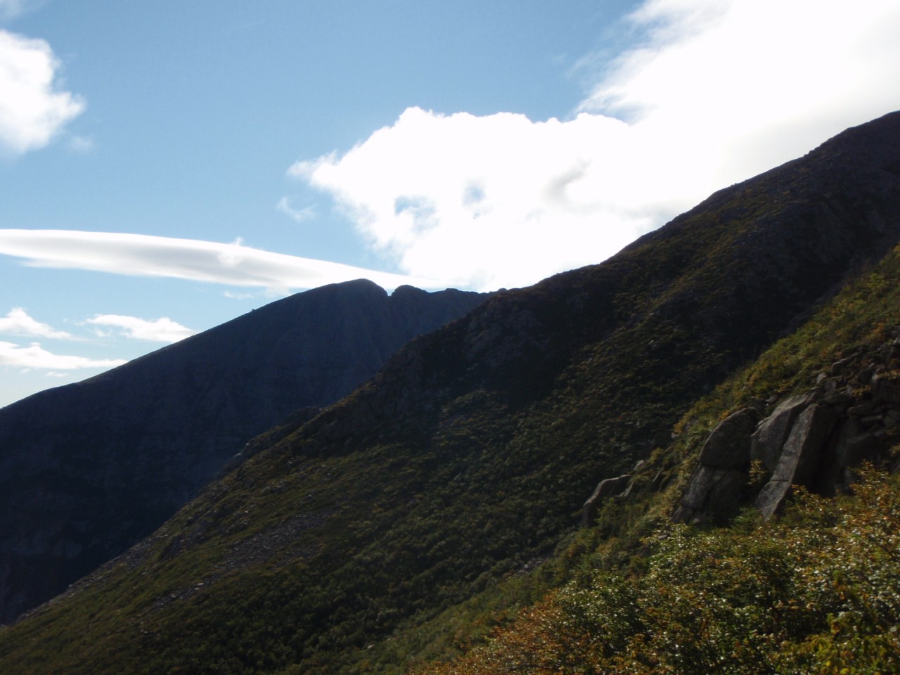
| The ridge that the Dudley Trail takes up to the Knife Edge - looks constantly steep (steep enough at least) |
 |
| Cathedral Ridge with Knife Edge behind |
 |
| Last shot of the Chimney - said to be the toughest part of the Knife Edge |
 |
| At Chimney Pond's pavilion |
 |
| He posed |
 |
| Last looks on the hike out to Roaring Brook |
 |
| I'll be back! |
We may not have gotten to do all we hoped to do, but we made it to both summits, and got a taste of the views possible. Someday (hopefully next year) I want to make it back and do more hiking on this mountain and in the park in general. 6.5 hours of driving just to the main gate, but it could be worse (my dad was 13 hours each way!).
Summary:
Peaks: Katahdin - Hamlin Peak (4756', NE4K), Katahdin - Baxter Peak (5268', NE4K)
Trails: Chimney Pond Trail (to/from Chimney Pond Campground), Saddle Trail + Northwest Basin Trail + Hamlin Ridge Trail + North Basin Trail + Chimney Pond Trail (Hamlin Peak), Saddle Trail (Baxter Peak)
Mileage: 3.3 miles (Roaring Brook to/from Chimney Pond), 4.7 miles (Hamlin Peak round trip form Chimney Pond), 5.0 (Baxter Peak round trip from Chimney Pond) -- 16.3 miles total
Elevation Gain: ~1400 feet (Chimney Pond from Roaring Brook), ~2000 feet (Hamlin Peak from Chimney Pond), ~2300 feet (Baxter Peak form Chimney Pond)
Don't let the miles/elevation fool you. These trails are not nearly as fast as those I am used to in the Whites! They are rougher, bouldery, and very steep in spots. Even Chimney Pond Trail wasn't great, with lots of rock hopping, but it wasn't terrible (probably rough at the end of a long dayhike though).


No comments:
Post a Comment