The weather for this hike was significantly better than the day before, where we were socked in all day. Instead it was to be clear blue skies for a trip to the Carter Range. Parking at the lot for the 19-Mile Brook Trail, I headed up said trail towards the hut. I made the decision early on that instead of taking the Carter Dome Trail up to Zeta Pass, I would continue all the way to Carter Notch and take the steep way up to the summit of Carter Dome, a route I've only done once before, on a hazy overcast day over 10 years ago. From there, the Carter-Moriah Trail would be followed over Mount Hight (not an official 4000-footer, but it has easily the best views on this range), South Carter, and Middle Carter, before a descent on the North Carter and Imp Trails
 |
| Some nice cascades along this trail, which as the name suggests, follows a brook |
 |
| An old dam along the trail - a nice swimming spot on a hot day |
 |
| Wildcat A towers over the Carter Lakes |
Reaching the notch in terrific time, I took a breather before starting what I knew was going to be a tough climb. In 1.2 miles, the Carter-Moriah Trail ascends 1550 feet, and the upper portion is significantly less steep than the lower portion. Slow and steady is the key here, and in relatively good order I made it to the side trail (marked "view") to an overlook next to Pulpit Rock, which commands a great view of Carter Notch from above. I was also able to pick out the view ledge near the summit of Wildcat A from here, and spotted someone on said ledge taking pictures.
 |
| Taking a picture of someone on Wildcat A taking a picture |
 |
| Carter Notch Hut far below next to the ramparts |
 |
| Pulpit Rock |
 |
| The Northern Presis from Pulpit Rock |
 |
| Wildcat Mountain from Pulpit Rock |
Continuing the ascent, I made it to the empty summit of Carter Dome. The climb, while stiff, didn't seem as bad as I remembered, though the previous climb on this route was with a full pack on a very humid day, so that may have had a lot to do with it. I spent a few moments poking around in the bushes around the summit clearing where the old fire tower used to be, not finding anything of note. The North-Western viewpoint was more overgrown than I remembered, but then again my last visit was in winter with several feet of snow on the ground. Nevertheless, my break was brief as I intended to make a longer stop at Mount Hight a short distance away, where I knew the view would be spectacular.
 |
| Carter Dome summit clearing |
 |
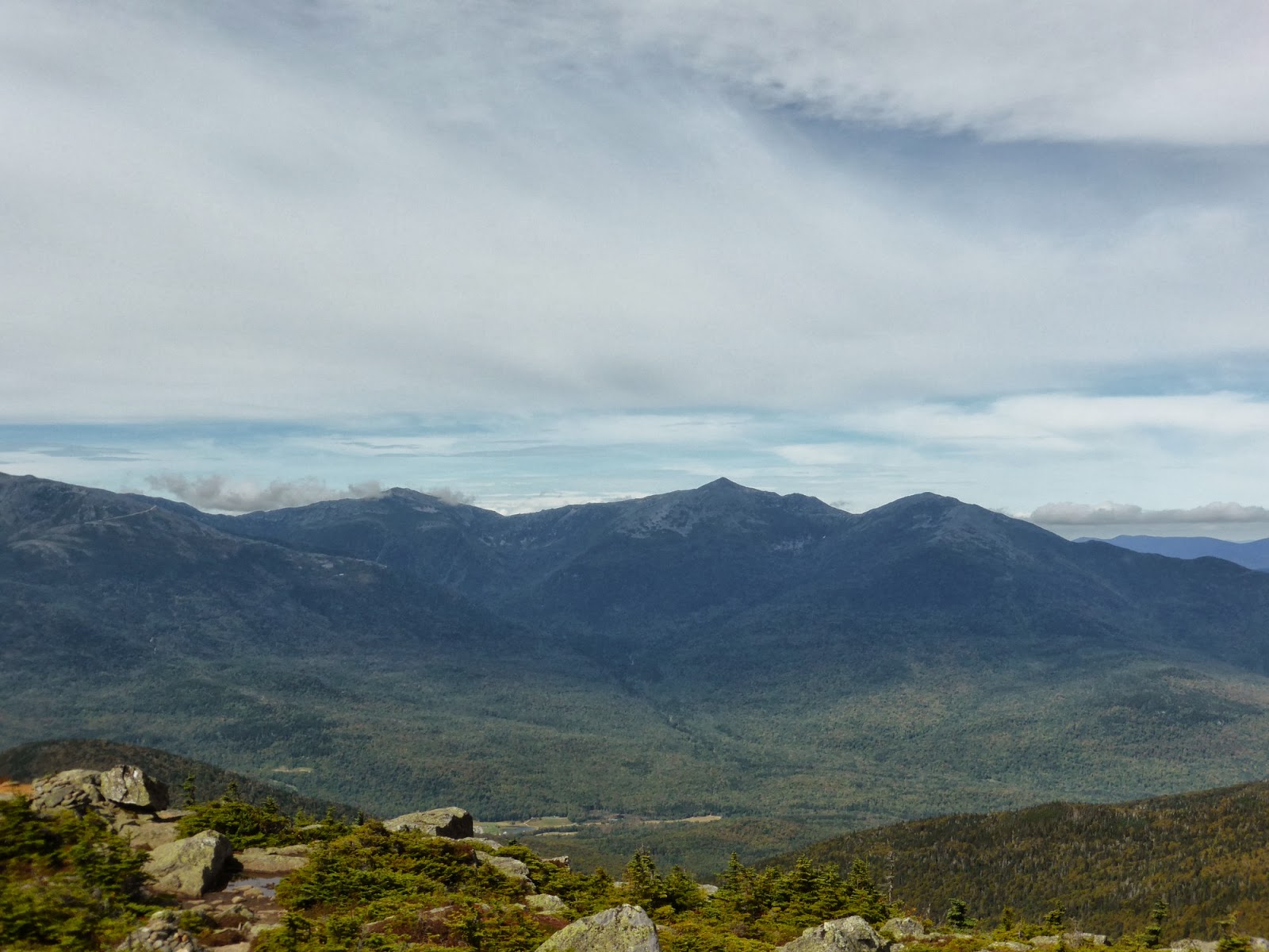
| The bald summit of Mount Hight, as seen from Carter Dome |
The walk over to Hight was uneventful aside from the massive mud bog in the col along the way, which required the use of a well-worn bypass through the woods. Once at Mount Hight, I had the desired 360-degree views. Making great time to this point (I had a bit of a deadline to be home by), I took a nice long break here. I did note that unfortunately the birch trees in the Wild River Valley were already all fully turned yellow, which means the hardwoods were not far behind. Since it was going to be a month before I could get up here for a hike again, it meant I would miss the peak foliage once again. Oh well, what can you do. Today was a beautiful day nonetheless, with views pretty much at their maximum.
 |
| Wild River Valley |
 |
| South (L) and Middle (RC) Carter from Mount Hight |
 |
| Jefferson (in clouds), Adams, and Madison |
 |
| Glen Boulder Trail and the Gulf of Slides |
 |
| The Eastern arm of Carter Dome into the Wild River Valley |
 |
| The alpine shoulder on Carter Dome that the Rainbow Trail crosses |
 |
| Washington and Jefferson from Hight |
Eventually prying myself away, I continued on to South Carter, after the steep descent to Zeta Pass from Mount Hight. I found the "stick sign" in the summit clearing to the side of the trail, and checked out the small viewpoint nearby as well. You find something new every visit! It had been a pretty quiet day on the trails to this point, with only scattered encounters with people to this point. After leaving South Carter, I would see no fewer than 18 people before reaching Middle Carter, which was a surprising amount considering.
 |
| Hight (L) and Carter Dome (R) from South Carter viewpoint |
The trek over to Middle Carter offers a couple nice viewpoints, which I made sure to fully enjoy, before making the summit itself, which is right alongside the trail and a couple small viewpoints again are nearby on short herd paths. Make sure to check these out, there are some unique views from some of these spots.
 |
| Hiking towards Middle Carter |
 |
| Summit of Middle Carter |
 |
| Wild River Valley from Middle Carter |
 |
| The Baldface Range |
 |
| Shelburne Moriah - need to explore that ledgy goodness one of these days! |
I had originally contemplated doing the short bushwhack to Mount Lethe (on the Trailwright's list, not that I am working on that list), but my time was starting to get short, and I didn't find a particularly encouraging point to enter the woods, so I left that one for another day. The boardwalk section on the way there though, was awesome as always. The steep, wet descent on the North Carter Trail went by without incident, as did the descent on the South side of the Imp Loop. About 3/4-mile from the trailhead, I hung a left on an old logging road that crosses the trail (you cannot miss it!) and followed that into the back of Camp Dodge, and once walking down the access road to the highway, I had a short ~3/10-mile walk back to my car. All told, a beautiful day in the woods, and I made it out a bit earlier than expected thanks to a fairly quick descent.
 |
| Boardwalk section North of Middle Carter on the Carter-Moriah Trail |
Summary:
Route: 19-Mile Brook Trail, Carter-Moriah Trail, North Carter Trail, Imp Loop (South end), logging road, roadwalk
Peaks: Carter Dome (4832', NH4K), Mount Hight (4675', TW72), South Carter (4430', NH4K), Middle Carter (4610', NH4K)
Mileage: 13 miles
Elevation Gain: 4650'
Book Time: 8hr 50min (actual 7hr 50min)


No comments:
Post a Comment