Once again, Columbus Day Weekend was the only weekend I could get up North in October this year. That is typically a very busy weekend up in the White Mountains. Still, I headed up, figuring I'd just start early, since my plans entailed hitting one of the most popular trails in the NorthEast. While I've summitted Mount Washington twice before (making it one of my least-summitted peaks on the 4000-Footer list actually), I've never done it from the East. So I planned a nice-sounding loop hike from Pinkham Notch which was mostly all on new-to-me trails.
The main objective was Tuckerman Ravine, and specifically climbing the headwall section of this trail, a segment that is only open for a handful of months a year due to how it accumulates the snow and is treacherous well into Summer most year. Since I stayed up North the night before, I was able to get a nice early start on the trail, leaving the parking lot around 7:10 in the morning. My hope was to beat the hordes that were likely to be packing this trail later in the day, and the still mostly-calm parking lot when I left was a good sign.
About 10 years ago I spent most of a week with the AMC working on the Lion's Head Trail up around the Lion's Head itself, and we camped nightly at Hermit Lake in one of the shelters. We hiked daily up via the Lion's Head Trail, so I had never been on the Tuckerman Ravine Trail in towards the headwall, but I knew roughly what to expect on the first segment to Hermit Lake. I made great time all the way to there, but first I made sure to stop at the spectacular Crystal Cascade roughly 4/10-mile in from the trailhead. This would be a great destination for young children or those not looking for anything too strenuous, and I spent a little while here playing with the camera, and actually got some nice shots.
 |
| Crystal Cascade |
 |
| Lower segment of Tuckerman Ravine Trail - basically like this up to Hermit Lake (aside from some steeper grades). |
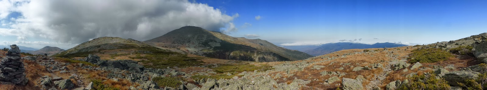
The trail passes the junction with the Boott Spur Trail (my planned descent route) and then steadily (but never steeply) climbs on an old road to the Hermit Lake. I passed a couple small groups of people in this stretch, and was in turn passed by a couple people, but really it was very quiet on the trail so far. I was really enjoying this hike, but was really looking forward to the headwall. Once I reached the Ranger Station at Hermit Lake, I got my first views of what was coming!
 |
| Hermit Lake Ranger Station with Lion's Head towering above |
 |
| The headwall of Tuckerman Ravine |
 |
| The Boott Spur cliffs |
 |
| Zoom-in on the headwall |
 |
| Some people topping out above the headwall and approaching Tuckerman Junction (upper right corner) |
A short break later, and I began the approach to the base of the headwall, and then began the climb in earnest. Honestly, the segment up the headwall went very quickly and before I knew it I was above the headwall. It climbs up to the right of many waterfalls pouring off the rocks before hanging a left and traversing above the steep cliffs before meeting the trail junction above the headwall, with pretty easy footing throughout. While climbing, I did notice that there was one heck of an undercast sitting off to the East. I've seen undercast one other time before (on Moosilauke on St. Patty's Day 2012), but this one was very impressive, and was completely blanketing even the Carter Range. There was nothing but a sea of white to the East into Maine! Even better, I had not run into a single sole since leaving Hermit Lake, I had the headwall all to myself!
 |
| No sign of the Carter/Wildcat Range to the East of Lion's Head! |
 |
| Now for the rock-hopping! |
While the headwall climb was brief and did not seem that bad, the last 8/10-mile to the summit was. This was classic Northern Presidential rock-hopping, with a rather steep grade to boot. The footing wasn't good in spots (lots of tippy rocks with big holes between), and coupled with the steep grade, this was not my favorite segment of trail ever. Still, I made it up in decent time, and was standing on the summit of Mount Washington a mere 3.25 hours after starting! At 10:30AM, the summit was busy, but not that bad, but I didn't hang around to get my picture taken at the summit sign (I did tag it on the way to the observation deck).
 |
| Mount Monroe and a sea of clouds |
 |
| Short line to get your picture! |
 |
| Busy, but not really for Mount Washington |
I knew the summit was only going to get busier, and soon headed off, opting to add a little more to my planned route since I was ahead of schedule. I took the Trinity Heights Connector and the Gulfside Trail down to the North and hooked onto the Westside Trail towards Lakes of the Clouds Hut for the extra redline. While heading down the Gulfside Trail, I saw 3 full cog trains a mere minute or two behind each other steaming uphill, guess I got going just in time! I've got to say, those bio-diesel engines just don't do it for me, the old coal-fired engines were way cooler (even if they are harder to run and worse on the environment).
 |
| Cog #1 |
 |
| Cog #2 |
 |
| Cog #3 |
 |
| Scattered clouds on the Northern Presidentials |
 |
| No undercast to the West |
The Westside Trail was mostly good in footing and fairly flat, and was a nice, and obviously lightly-traveled route around the summit cone of Mount Washington, and in short order I was on the Crawford Path heading to Lakes of the Clouds Hut. Here I started to run into the crowds, as expected, but I've seen worse, and I didn't stop at the hut for long. The climb up to Monroe, while steep with a couple minor scrambles, goes quickly, and in short order I was on this summit for the 3rd time as well. Just in time, as the clouds over the Southern Presidentials were breaking up, allowing for views of Eisenhower, Pierce, and towards the Pemi.
 |
| Washington from the Crawford Path near Lakes of the Clouds Hut |
 |
| Mount Monroe looming over the hut |
 |
| Lakes of the Clouds Hut and Mount Washington |
 |
| The survey pin on the summit of Mount Monroe - I have only a couple left to find now! |
 |
| The Crawford Path bypassing the summit of Mount Monroe |
 |
| The Southern Presidentials from Mount Monroe |
After returning to the hut, I picked up the Camel Trail to cut over to the Davis Path, and then to Boott Spur. The Camel Trail was a nice trail, with unique views from the flats, and some nice cairns strung along. I saw no one on this stretch, and only a couple people on the short stretch of the Davis Path I was on, but that changed when I hit the Boott Spur Trail. Interestingly, there were several dozen people I ran into along this stretch, all still heading up to the summit.
 |
| Mount Monroe from the Camel Trail |
 |
| Many cars on the summit now! |
 |
| Clouds spilling over the end of the Wildcat Range into Pinkham Notch |
With a short break at Boott Spur (and a scramble up to the top of it just off-trail), I headed down the Boott Spur Trail. Initially heading steeply down over some rough footing, the views are terrific into Pinkham Notch (well, that was mostly filled with undercast at the time!), and into Tuckerman Ravine. After reaching the true treeline, there is soon a viewpoint spur to Harvard Rock, which was the last views I had on this trail (there was another marked viewpoint lower down, but it was in the middle of the cloud deck).
 |
| Split Rock |
 |
| Yea, it's a little ways to the summit, especially the way I came! |
 |
| View of the ravines from Harvard Rock (on the left) |
The Boott Spur Trail never lets up for long, but maintains the fairly steep, and somewhat rough footing all the way down to the Tuckerman Ravine Trail (it does drop 3200 feet in 2.9 miles after all). It seemed it never wanted to come to an end, but eventually it did of course, though not before a final surprise of a steep ladder (I need to read the trail descriptions less than a month before I do a hike...). From there it was a quick and easy cruise out to the car a couple tenths of a mile away, seeing many hikers coming off the Tuckerman Ravine Trail (I saw all of 3 people between Boott Spur and the trail junction).
 |
| Steep ladder shortly before the Tuckerman Ravine Trail junction. |
It was a great loop, though I'm not sure I want to descent the Boott Spur Trail again. With the early start, I had a mostly quiet day on the trails despite hitting some of the most popular trails in the White Mountains, and I finally summitted Mount Washington from the East. Tuckerman Ravine's headwall was awesome, and a segment of trail I will definitely repeat again someday!
Summary:
Route: Tuckerman Ravine Trail, Trinity Heights Connector, Gulfside Trail, Westside Trail, Crawford Path, Mount Monroe Loop, Camel Trail, Davis Path, Boott Spur Trail
Peaks: Mount Washington (6288', NH4K), Mount Monroe (5372', NH4K), Boott Spur (5500', TW72)
Mileage: 12.7 miles (7.1 miles new red-lines)
Elevation Gain: 5300ft
Book Time: 9 hours (actual time 9hr 5min)


No comments:
Post a Comment