Route: Tunnel Brook Trail, Tunnel Brook Road, Benton Trail, Carriage Road, South Peak Spur, Hurricane Trail, Glencliff Trail
Peaks: Moosilauke (4802', NH4K), Moosilauke - South Peak (4523', NH4K)
Mileage: 16.8 miles
Elevation Gain: 5100ft
Book Time: 11hr (actual 8hr 10min)
After finally picking a spot to go hiking for this weekend, I settled on knocking off some more straggler redlines on Mt. Moosilauke. I love this mountain for its great views, generally decent footing, and huge variety of loop hike options. This would be the biggest loop I've done on this peak yet, and it was probably my favorite when all was said and done!
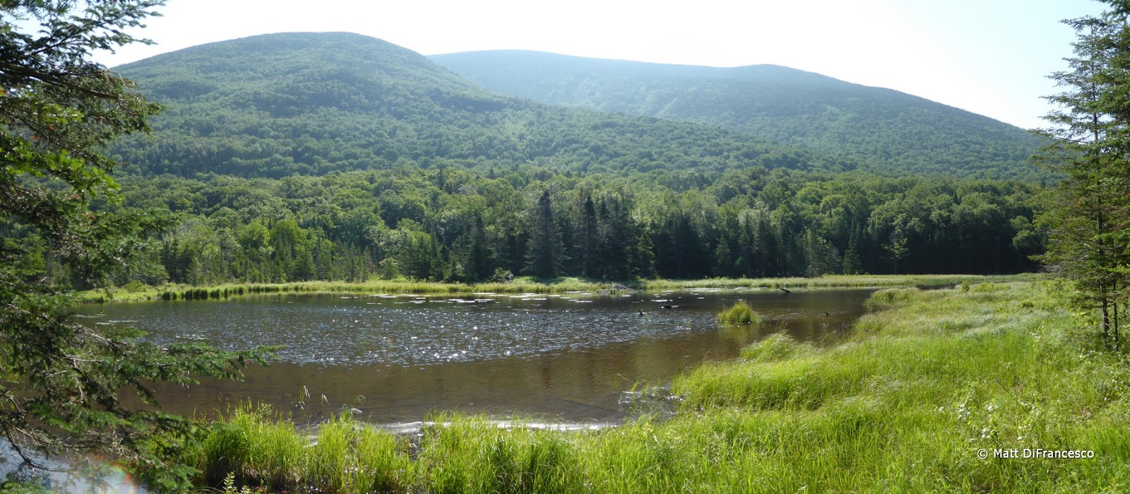
For this hike, I parked at Glencliff in the trailhead parking lot, and walked down the road to Long Pond Road (which was gated less than 1/10-mile in) and down that to the Southern end of the Tunnel Brook Trail. This trail gently climbs through Tunnel Brook Ravine, passing several beaver ponds along the way. The trail is gradual, the footing very good for the most part, and it was a very enjoyable stretch of trail that I intend to revisit again someday! There are a few tricky-to-follow spots in among the beaver ponds, along with the usual mud and occasional washed-out section of trail that accompanies such stretches, but the views of the ponds, and across to the slides of Mount Clough and up to the South Peak of Moosilauke were great. Do note, however, that a few of the pond outlet/stream crossings, while not wide nor particularly deep, had minimal to no rocks or branches to cross on. One crossing I had to splash through 1-foot deep water, and I don't like wet feet, luckily my gaiters held out the water long enough to cross!
 |
| Off on the first of 3 new trails on the day! |
 |
| About a mile in was this pond, complete with mini "boathouse", a concrete spillway, footbridge, bench, and 2 life rings! |
 |
| A typical section of the Tunnel Brook Trail up to Mud Pond. |
 |
| First views from Mud Pond |
 |
| Mt. Moosilauke - South Peak from Mud Pond. |
 |
| One of a few non-dangerous, but somewhat tricky, stream/pond outlet crossings. |
 |
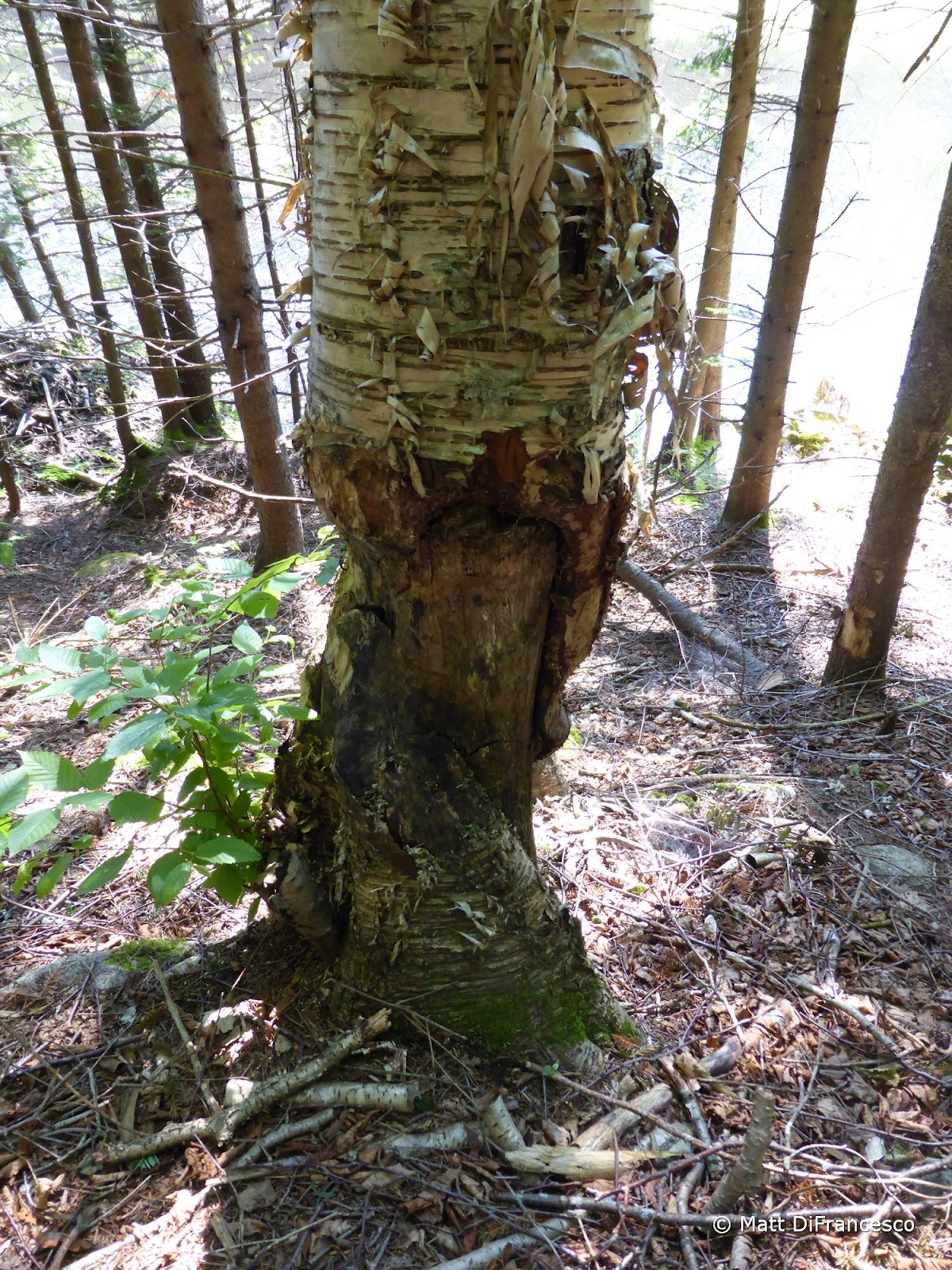
| Hmm, looks like a Beaver was here a while back. |
 |
| Yea, beavers definitely live/lived here! |
 |
| Mt. Clough |
 |
| Mt. Clough |
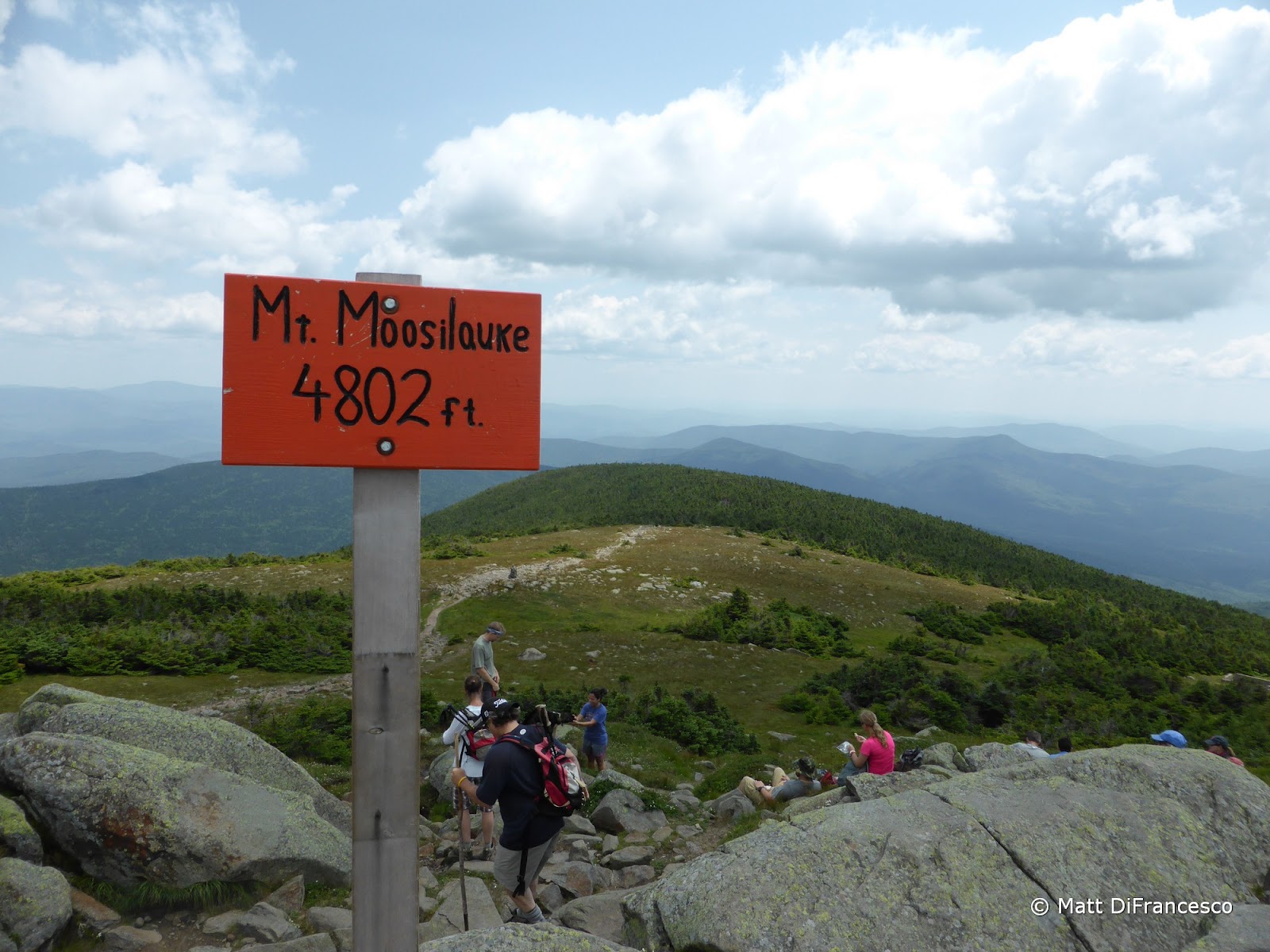
From the Northern trailhead (which is a bit brushy for the first 50-100ft from the parking lot) I walked ~0.9 miles down the closed-since-Hurricane-Irene Tunnel Brook Road (I'm not sure when, or if, this road will re-open) to the Benton Trail and headed up that trail to the summit. Just below the junction with the Beaver Brook Trail I ran into the first people I'd seen since I left my car, a group doing a traverse of the Beaver Brook and Benton Trails. I don't think the Benton Trail is going to be a favorite trail to the summit for me, but the grades and footing for the most part were decent. It was just a fairly boring hike in the woods, aside from one neat viewpoint partway up. The summit was mobbed (I haven't hiked a popular White Mountain peak in July in over 10 years, the last few years I've been in quiet corners of Maine), and the skies extremely hazy, but I found a spot and took a much-needed nap (OK, it was maybe 15 minutes at most) before having a snack and heading off for South Peak.
 |
| Short road walk done, off to the next new trail! |
 |
| Lookout across Little Tunnel Brook Ravine |
 |
| The Kinsmans from the Benton Trail |
 |
| Done with the Benton Trail, now for some familiar trails for a few miles. |
 |
| Approaching the summit. |
 |
| Rather hazy, but still nice! |
 |
| The Kinsmans behind the low ridge of Mt. Wolf, with Franconia Ridge in the background. |
 |
| Mountain Sandwort was blooming all over the place. |
 |
| The Tripyramids, with Mt. Tecumseh on the right. |
 |
| It doesn't show here, but the summit was REALLY busy! |
 |
| The Gorge Brook Trail as it reaches the summit. |
 |
| South Peak from Moosilauke |
 |
| Benton Sugarloaf (left pointy peak) and Black Mountain. |
I had a decision. Head down the Glencliff Trail, or add about 3 miles to the day and head down the Carriage Road and take the Hurricane Trail back to Glencliff (which was the original plan). I opted for the latter (blasted red-lining!). The Hurricane Trail between the Carriage Road and the Glencliff Trail is described in the White Mountain Guide as being rough, muddy, and steep in places. But I found a lot of very new trail work on the way up to Hurricane Mountain, a bunch of new water bars, a footbridge over a crossing, and flagging marking spots that I assume means more work is coming. I ran into a trail crew about 2/3 of the way up the ascent and thanked them for their work. Yes, the trail got rougher, muddier, and steeper above there (and on the first part of the descent), but I suspect more work is coming. For the DOC it is a rough trail, but it's great to see it getting some tlc!
 |
| Off to South Peak. |
 |
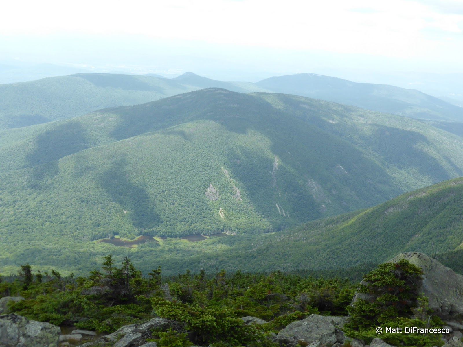
| View of Mt. Clough and Tunnel Brook Ravine from Moosilauke's South Peak. |
 |
| Mud Pond from Moosilauke - South Peak. I was down there just a few hours ago! |
 |
| Moosilauke from South Peak. |
 |
| It's still busy up on the main peak! |
 |
| Just before reaching the lower Carriage Road/Hurricane Trail junction was this bridge. |
 |
| The bridge has a name! |
 |
| Heading to the left of this sign, for the new-to-me 3-mile Western stretch of the Hurricane Trail. |
 |
| Hurricane Trail, check! |
Despite the hot (low 70s on the summit, thankfully a nice teens to low 20s breeze), and humid day, and being off the trails for almost a month, I did the 16.8 miles in just over 8 hours, which for me is a very fast time. That includes 30 minutes lounging on the summit! It was also pretty neat netting 11 miles of new red-lines on a mountain I've now summitted 6 times (and 5 of those times used at least some new trails)!


No comments:
Post a Comment